1169 Sicily earthquake
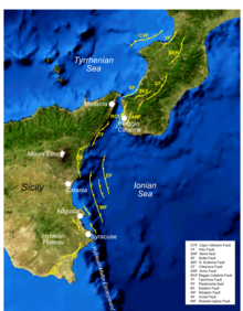
Most of the damaging earthquakes occur on the Siculo-Calabrian rift zone, a zone of extensional faulting which runs for about 370 kilometres (230 mi), forming three main segments through Calabria, along the east coast of Sicily and immediately offshore, and finally forming the southeastern margin of the Hyblean Plateau, a carbonate platform in southeastern Sicily.
[4] In the southern part of the eastern coast of Sicily, investigations have identified a series of active normal dip-slip faults, dipping to the east.
[3] Intensities of X (Extreme) have been estimated for Catania, Lentini and Modica, IX (Violent) at Syracuse and Piazza Armerina and VIII (Severe) at Santi Pietro e Paolo and Messina.
[3] The tsunami affected most of the Ionian coast of Sicily and caused inundation from Messina in the north to the mouth of the Simeto River in the south.
[8] The tsunami is also thought to be responsible for moving several large boulders from the middle of the sublittoral zone onto the coast between Augusta and Syracuse.
Catania Cathedral collapsed, killing the Bishop John of Ajello, 44 of the Benedictine monks, and many others who were crowded into the building for the feast of St.
[3] In a contemporary account, Hugo Falcandus described the effects on the Arethusa spring in Syracuse, which increased its rate of flow greatly and became salty.