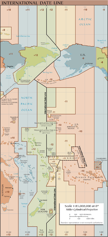
180th meridian
On Earth, the prime and 180th meridians form a great ellipse that divides the planet into the Western and Eastern Hemispheres.
The antimeridian passes mostly through the open waters of the Pacific Ocean but also runs across land in Russia, Fiji, and Antarctica.
An important function of this meridian is its use as the basis for the International Date Line, which snakes around national borders to maintain date consistency within the territories of Russia, the United States, Kiribati, Fiji and New Zealand.
Starting at the North Pole of the Earth and heading south to the South Pole, the 180th meridian passes through: The meridian also passes between (but not particularly close to): The only places where roads cross this meridian are in Fiji and Russia.
This often makes it non-trivial to do simple tasks (like representing an area, or a line) over the 180th meridian.