1886 eruption of Mount Tarawera
Lake Rotomahana, the former site of the terraces, significantly expanded as a result of the eruption as it filled portions of the newly formed rift valley.
[4][6] Over the past 21,000 years, an estimated 80 cubic kilometres (19 cu mi) of magma and volcanic material has collectively been ejected from 40 vents in the caldera in 11 distinct episodes of activity.
[4] Mount Tarawera itself is a rhyolitic dome volcano that began forming roughly 23,500 years ago in the southeast of Ōkataina Caldera.
[7]: 309 The mountain was built up over a series of four major volcanic eruptions prior to 1886, each generating significant rhyolitic lava and pyroclastic material.
[8][15]: 1 To reach the area, visitors typically came from Auckland to Tauranga via train or coastal steamer, transferring to horse-drawn coaches for the journey to Ōhinemutu (now part of Rotorua) and on to Te Wairoa.
This trade brought an estimated £1800 per year to the economy of Te Wairoa (equivalent to roughly NZ $425,000 in 2023), primarily from boat trips, entertainment, and souvenir photography or sketches.
On 31 May 1886, eleven days prior to the eruption, a group of tourists returning from the Terraces claimed to have seen a waka approaching their boat before disappearing into the mist.
Witnesses described two rows of occupants, one of which was "standing wrapped in flax robes, their heads bowed and, according to Māori eyewitnesses, their hair plumed as for death" using huia and kōtuku feathers.
[16] Tūhoto Ariki, a tohunga at Te Wairoa, declared the tourists had sighted a waka wairua (spirit canoe) which was to herald the destruction of the region.
[8] The evening before the eruption was a clear night, with nothing unusual until shortly after midnight on the morning of 10 June 1886, when a series of more than 30 increasingly strong earthquakes were felt in the Rotorua area.
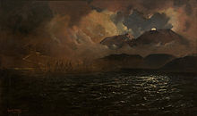
[20]: 43 By 2:30 a.m., all three of Mount Tarawera's peaks had erupted, blasting three distinct columns of smoke and ash thousands of metres into the sky and causing a large amount of volcanic lightning.
[20]: 43 This explosion distributed a mix of wet ash and lapilli over an area of 10,000 square kilometres (3,900 sq mi), with heavy accumulations of this mud destroying several villages near to the mountain, causing the majority of deaths associated with the eruption.
[8] Material continued to be ejected from craters at Rotomahana and Okaro for up to ten days after the initial eruption, although these declined in frequency and intensity.
[20]: 47 The noise from the eruption was reported across the country, including South Island towns such as Kaikōura, where it was thought to be a ship in distress, Blenheim, where the shock-wave rattled windows, and Christchurch, over 800 kilometres (500 mi) away.
[2] One of these search parties, upon reaching the former sites of Moura and Te Ariki on the southeastern shore of Lake Tarawera, found no survivors at either village or at Waingōngongo.
[2] The village's wharenui, Hinemihi, was later taken to England and erected in the grounds of Clandon Park, the seat of the 4th Earl of Onslow, who had been Governor of New Zealand soon after the eruption.
The latter estimate comes from oral accounts from Ngāti Hinemihi, but is inconsistent with censuses undertaken of the Māori population in the area and pre-eruption understandings of the number of people residing there.
[30]: 19 Accounts from the aftermath describe the forest as "a mass of broken limbs and riven stumps, wrenched and torn to an extent that renders the wood utterly useless.
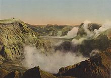
Rapid erosion caused the formation of steep v-shaped ridges and valleys in the deepest areas of ashfall, providing scientists with a cross-section of the eruption phases.
[20]: 46 [29]: 139–140 Today, the mountain is covered by regenerating bush and shrubland, with species including mānuka, monoao, mingimingi, and kānuka – although these are coming under increasing threat from introduced wilding pines.
[36]: 389 Most famously, the eruption was long believed to have caused the destruction of the Pink and White Terraces, New Zealand's greatest tourist attraction at the time.
In the immediate wake of the eruption, guides in the area explored the new landscape for any sign of the terraces, refusing to believe that they had been destroyed, despite a lack of evidence at the time which would suggest their survival.
[25] The drastically changed landscape and the apparent lack of a pre-eruption survey map prevented any conclusive fate to be determined, allowing a range of opposing viewpoints to persist.
[38]: 182 In 2011 and to coincide with the 125th anniversary of the eruption, scientists from GNS Science announced that they had rediscovered parts of both the Pink and White Terraces 60 metres (200 ft) under the surface of Lake Rotomahana using autonomous underwater vehicles.