1911 Kebin earthquake
Registering at a moment magnitude of 8.0, it killed 452 people, destroyed more than 770 buildings (which was almost all of the city) in Almaty, Kazakhstan, and resulted in 125 miles (201 km) of surface faulting in the valleys of Chon-Kemin, Chilik and Chon-Aksu.
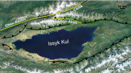
[3] In the Chong-Kemin and Chilik valleys, and on the shoreline of Issyk Kul, a complex zone of surface rupture was identified by fieldwork immediately following the earthquake.
The outcrop pattern of the Aksu segment rupture indicates a low-angle thrust, possibly steepening with depth, with a maximum vertical offset or 3–5 m, decreasing steadily to the east.
The Kaindy landslide, with a volume of 15 x 106 m3, was formed of a mass of limestone that buried a group of yurts and killed 38 people.
The Ananevo rockslide also had a volume of about 15 x 106 m3, and was formed of weathered granitic material, with a 250 m high backscarp that is still visible.