1960 eruption of Kīlauea
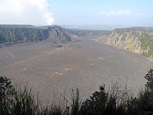
At the summit of the volcano, earthquakes hit the caldera rim and three collapses affect the floor of the Halemaʻumaʻu crater, with lava appearing as a remnant of a previous eruption.
[5] The Volcanologists' fears were confirmed when a first seismic crisis appeared just after the end of the eruption of Kīlauea Iki on December 21, 1959, followed by a second in the first week of January 1960.
[5] With roads threatening to become impassable, the ground constantly vibrating and the rumblings that accompany the strongest earthquakes, the 300 inhabitants of Kapoho spontaneously left their village, which was completely evacuated by early evening.
[5] The subsidence of the ground and the sudden drop in the intensity of the earthquakes, some 1,500 still recorded in the afternoon of January 13, indicated to volcanologists the imminence of the eruption.
[6] In the evening, one of the fissures is shaken by explosions caused by the vaporization of groundwater of uncertain origin, either from the brackish water table or from seawater seeping into the faults.
[6] The plumes of water vapor expelled violently from the fissure over eleven hours are strewn with fragments of lava, both glowing and cooled, all amid a deafening noise resembling "a huge blowtorch or a giant steam engine".
The surrounding area is then covered with a thin deposit of fine fragments of volcanic glass and salt crystals, expelled with the steam and carried away by the wind.
This small body of water, linked to the ocean by a narrow channel, was formed by a previous subsidence of the graben during the eruption of Kīlauea in May 1924.
[6] After several hours of advancing and stagnating phases, the lava flow entered Higashi Pond at channel level on January 16 at around 7:45 pm, cutting it off from the ocean.
[6] As the lava advances, it threatens and then destroys infrastructure, the first being the coastal road in the early hours of the eruption, and landscapes such as Higashi Pond.
[6] The flow, which had reached the gates of the village, began to enter the town as a result of the collapse of the southern flank of the slag cone, which had discharged large quantities of lava in the direction of the houses.
[6] The pressure exerted against the dike and the Puʻu Kukae caused the lava to seep into the volcanic cone of loosely consolidated ash.
[6] Managing to pass under the dike and emerge on the other side, the lava continued its progression south-eastwards, reaching the school, which was destroyed between 10 a.m. and 12.30 pm, and the cemetery.
[6] At the same time as the fight against the advancing lava was being organized to protect Kapoho, another dike was built from January 21, on the other side of Puʻu Kukae, between this volcanic cone and the Pacific Ocean, along a faint ridge.
With a length of 1.6 kilometers, it was intended to spare the Kapoho Beach district and the coastguard installations at Cape Kumukahi, including the lighthouse, from destruction.
On the day of Kapoho's destruction, January 27, a slag heap a kilometer long and several dozen meters thick was formed in a northeasterly direction when large quantities of tephra were discharged from the main fountain and covered the lava lake.
This exogenous magma is thought to have originated from the 12 × 106 cubic meters remnant of the late 1959 eruption of Kīlauea Iki, which made its way under the east rift to Kapoho.
[6] After a final burst in which the fountains reached a height of 300 meters, they gradually dried up and stopped spewing lava on February 19, marking the end of the eruption.
The highest volcanic cone, rising more than a hundred meters above the surrounding terrain, is named Puʻu Laimana in honor of the Lyman family who owned the land where the fissures opened.
From January 17, the volcano's summit began to deflate, indicating the emptying of the magma chamber via the fissures opened at Kapoho.
It was accompanied by small earthquakes from January 23 onwards, up to several hundred a day, caused by fracturing of the rock surrounding the magma chamber due to changes in pressure stress.
Numerous fissures open up a few kilometers south of Halemaʻumaʻu, one of them forming a small, fifteen-centimeter-high escarpment across the Hilina Pali road.
[6] A community of 300 inhabitants, a school, churches, roads, and crops were destroyed and covered by several meters of lava that advanced out to sea, modifying the coastline by bringing Cape Kumukahi, Hawaii's easternmost point, a little further east.