Green Line (Israel)
[10] After the Six-Day War, the territories captured by Israel beyond the Green Line came to be designated as East Jerusalem, the West Bank, the Gaza Strip, and the Golan Heights.
[15] The sections of the Green Line that delineate the boundaries between Israel, the West Bank and Gaza run through heavily populated regions.
Consequently, the Green Line underwent various slight adjustments, and special arrangements were made for limited movement in certain areas.
[16] According to Avi Shlaim, in March 1949 as the Iraqi forces withdrew and handed over their positions to the Jordanian legion, Israel carried out Operation Shin-Tav-Shin which allowed Israel to renegotiate the ceasefire line in the Wadi Ara area of the northern West Bank in a secret agreement that was incorporated into the General Armistice Agreement.
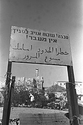
[17] During the war in 1947–48, Jews residing east of what subsequently became the Line, including the Jewish Quarter of the Old City, were taken prisoner by the Jordanians.
[11] On July 8, 1948, the Jewish inhabitants of Kfar Darom and Naharayim were evacuated by Israel due to military pressure by Egypt and Jordan.
[18] From August to September 2005, Israel implemented a unilateral disengagement plan in which the entire Jewish population of the Gaza Strip was evacuated.
In 2006, Ehud Olmert proposed a convergence plan that called for Israel to disengage, unilaterally, if necessary, from much of the West Bank (east of the line).
[27] In a December 1969 speech, US Secretary of State William P. Rogers said that "any changes in the pre-existing [1949 armistice] lines should not reflect the weight of conquest and should be confined to insubstantial alterations required for mutual security.
In a footnote, he wrote: "It should be added that the armistice agreements of 1949 expressly preserved the territorial claims of all parties and did not purport to establish definitive boundaries between them.
"[28] The question of whether, or to what extent, Israel should withdraw its population and forces to its side of the Green Line remains a crucial issue in some discussions surrounding the Israeli–Palestinian conflict.
[29] Although disputed by Israel, United Nations Security Council Resolution 242 (UNSC 242)[30] has declared the interpretation of international law regarding Palestinian Territory.
[32] In 2008 Al Jazeera and Haaretz both reported that elements in the Palestinian leadership, including Hamas, have called for a two-state settlement based on the pre-June 1967 borders (the Green Line).
A 2011 study found that, because of security concerns, 77 per cent of Israelis oppose returning to pre-1967 lines, even if it would lead to peace between Israel and neighboring Arab states.
[46] The Israeli West Bank barrier constructed in the early 21st century is, in parts, kilometres away from the Green Line and most lies within Palestinian territory.
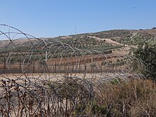
[47] According to Hebrew University geographer Ilan Salomon, the Green Line can be discerned from space via satellite; it is marked by pine forests planted by the Jewish National Fund to demarcate Israeli territory.
Salomon and Larissa Fleishman conducted a 2006 study regarding Israeli students' knowledge of the location of the Green Line, and they found that not much more than one third could identify its placement.
They learned that "students who identify with left-leaning parties are more familiar with the location of the West Bank and the Gaza Strip, can sketch them more accurately and are also more aware of the nature of borders.