1983 Sea of Japan earthquake
The northwestern side of Honshu lies on the southeastern margin of the Sea of Japan, an area of oceanic crust created by back-arc spreading from the late Oligocene to middle Miocene.
The focal mechanism indicates reverse faulting and the distribution of aftershocks is consistent with movement on a thrust plane dipping at 30° to the east.
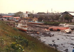
[2] The first wave of the tsunami struck the coast about 12 minutes after the earthquake, with a maximum run-up height of 14.9 m (49 ft) recorded on the Oga Peninsula.
[7] The initial models of the earthquake were unable to reproduce the short time interval between the shock and the first wave arrival at the coast.
[8] Offshore both mass failure deposits and turbidites have been observed that are dated to later than 1954 from high caesium-137 levels in the overlying sediments.
[9] Much of the earthquake damage was due to soil liquefaction, causing the collapse of houses and a number of road and rail accidents.