2006 Yogyakarta earthquake
Several factors led to a disproportionate amount of damage and number of casualties for the size of the shock, with more than 5,700 dead, tens of thousands injured, and financial losses of Rp 29.1 trillion ($3.1 billion).
Mount Merapi lies nearby, and during its many previous historical eruptions, large volume lahars and volcanic debris flowed down its slopes where settlements were later built.
Few seismometers were operating in the region, but a group of temporary units that were set up following the mainshock recorded a number of aftershocks that were east of the Opak River Fault and were aligned along a 20 km (12 mi) zone striking N°50E.
Several data sets (one captured in April 2006 and another post-earthquake batch from June) were collected from an instrument on board the Advanced Land Observation Satellite and were compared to each other to show potential ground deformation patterns.
[11] In 2006, Mount Merapi had not been active for more than four years, but on May 11 a pyroclastic flow triggered the evacuation of more than 20,000 people from the northern sector of Yogyakarta.
[12] A separate post-event study looked at the relationship with the layer of sediment and the occurrence of soil liquefaction during earthquakes near Bantul.
The type and properties of sediment control the occurrence and distribution of liquefaction, and other environmental conditions (like the water table) also play a part, as well as the peak ground acceleration of the earthquake.
[13] Altogether, eleven densely populated districts comprising 8.3 million people were affected, but the regencies of Bantul, Sleman, Gunung Kidul, Kulon Progo, Klaten, and the city of Yogyakarta were especially hard hit.
[14] With 154,000 houses destroyed and 260,000 units experiencing damage, the event was one of the most costly natural disasters in the previous ten years.
Low quality materials and improper construction styles led to unreinforced masonry buildings being responsible for the large loss of life and the high number of injuries.
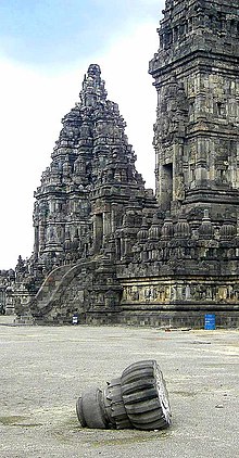
The site, which has experienced about 16 earthquakes since the 9th-century (including the 2006 event), consists of three yards of varying sizes with different stone block temples, and was rediscovered by a Dutch explorer in 1733.
[16] Many countries and organizations offered foreign aid to the devastated region, but the actual amounts delivered/received often varied from these figures, as in the case of other disasters.
[33] The government was slow to implement assistance in reconstructing private houses, leading many homeowners to repair or rebuild their homes either by themselves or with community help.