3D scanning
3D scanning is the process of analyzing a real-world object or environment to collect three dimensional data of its shape and possibly its appearance (e.g. color).
Other common applications of this technology include augmented reality,[1] motion capture,[2][3] gesture recognition,[4] robotic mapping,[5] industrial design, orthotics and prosthetics,[6] reverse engineering and prototyping, quality control/inspection and the digitization of cultural artifacts.
These scans have to be brought into a common reference system, a process that is usually called alignment or registration, and then merged to create a complete 3D model.
Both techniques tend to use infrared light-emitting diodes attached to the scanner which are seen by the camera(s) through filters providing resilience to ambient lighting.
Hand-held laser scanners can combine this data with passive, visible-light sensors — which capture surface textures and colors — to build (or "reverse engineer") a full 3D model.
A real-time scanner using digital fringe projection and phase-shifting technique (certain kinds of structured light methods) was developed, to capture, reconstruct, and render high-density details of dynamically deformable objects (such as facial expressions) at 40 frames per second.
These techniques produce a discrete 3D volumetric representation that can be directly visualised, manipulated or converted to traditional 3D surface by mean of isosurface extraction algorithms.
Although most common in medicine, industrial computed tomography, microtomography and MRI are also used in other fields for acquiring a digital representation of an object and its interior, such as non destructive materials testing, reverse engineering, or studying biological and paleontological specimens.
[36] Lidar and other terrestrial laser scanning technology[37] offers the fastest, automated way to collect height or distance information.
[38] Commercial applications of both airborne lidar and ground laser scanning technology have proven to be fast and accurate methods for building height extraction.
Most buildings are described to sufficient details in terms of general polyhedra, i.e., their boundaries can be represented by a set of planar surfaces and straight lines.
Using laser scans and images taken from ground level and a bird's-eye perspective, Fruh and Zakhor present an approach to automatically create textured 3D city models.
Using an airborne laser altimeter, Haala, Brenner and Anders combined height data with the existing ground plans of buildings.
Compared to results of automatic procedures, these ground plans proved more reliable since they contain aggregated information which has been made explicit by human interpretation.
Another low-power application uses structured light projection systems for solar cell flatness metrology,[40] enabling stress calculation throughout in excess of 2000 wafers per hour.
Notable software used for 3D data acquisition using 2D images include e.g. Agisoft Metashape,[48] RealityCapture,[49] and ENSAIS Engineering College TIPHON (Traitement d'Image et PHOtogrammétrie Numérique).
This approach is motivated by the fact that only robust and accurate feature points that survived the geometry scrutiny of multiple images are reconstructed in space.
An augmented reality menu for the Madrid restaurant chain 80 Degrees[66] 3D laser scanning is used by the law enforcement agencies around the world.
[71] A group of history students at Vancouver iTech Preparatory Middle School created a Virtual Museum by 3D Scanning more than 100 artifacts.
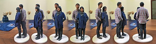
[74][75] The combined use of 3D scanning and 3D printing technologies allows the replication of real objects without the use of traditional plaster casting techniques, that in many cases can be too invasive for being performed on precious or delicate cultural heritage artifacts.
The resulting digital 3D model was fed to a rapid prototyping machine to create a real resin replica of the original object.
Approximately in the same period a research group from IBM, led by H. Rushmeier and F. Bernardini scanned the Pietà of Florence acquiring both geometric and colour details.
[83] In 2003 the so-called Digital Hammurabi project acquired cuneiform tablets with a laser triangulation scanner using a regular grid pattern having a resolution of 0.025 mm (0.00098 in).
[84] With the use of high-resolution 3D-scanners by the Heidelberg University for tablet acquisition in 2009 the development of the GigaMesh Software Framework began to visualize and extract cuneiform characters from 3D-models.
A fire on March 16, 2010, burned down much of the Muzibu Azaala Mpanga structure, and reconstruction work is likely to lean heavily upon the dataset produced by the 3D scan mission.
[89] In 2005, Gabriele Guidi, et al. scanned the "Plastico di Roma antica",[90] a model of Rome created in the last century.
The chairside systems are designed to facilitate the 3D scanning of a preparation in vivo and produce the restoration (such as a Crown, Onlay, Inlay or Veneer).
Especially the geometry of the metal parts must be checked in order to assure that they have the correct dimensions, fit together and finally work reliably.
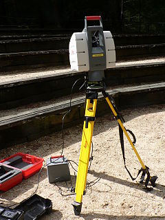
White-light or laser scanners accurately digitize objects all around, capturing fine details and freeform surfaces without reference points or spray.
Graphic comparison charts illustrate geometric deviations of full object level, providing deeper insights into potential causes.