A4232 road
The road was conceived in the early 1970s, and planning by South Glamorgan County Council began in the late 1970s.
At that stage the road was planned to be completed by 1995 and would relieve Ely, Grangetown, Butetown and East Moors of through traffic and provide a fast link to the national motorway network via the M4 and A48(M).
Much of the funding for the road had been grant aided from the European Community and the UK Government on the basis that it would improve the economic viability of the area and bring in new jobs and industry.
In 2006 variable message signs were installed on the Capel Llanilltern – Culverhouse Cross Link Road by Techspan Systems to display warning messages about road and weather conditions, accidents, congestion and major events in the area.
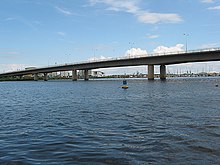
The Grangetown Viaduct (Welsh: Traphont Trelluest) is approximately 1 km (0.62 mi) in length and is said to be the longest glued segmental bridge in the United Kingdom.
In 1987 South Glamorgan County Council had intended to build a viaduct cross the River Taff and then go onto an elevated section through Butetown "on stilts".
[7] But the newly formed Cardiff Bay Development Corporation along with local residents objected to the scheme that they said would cut through Butetown and split the community, creating an unnecessary physical barrier between the two areas to the north and south of the link road.
[21] South Glamorgan County Council originally awarded the contract for the management, installation, testing and commissioning of all electrical and mechanical services for the tunnel, and the water pumping stations to EI·WHS Ltd.
[20] Immediately to the east of the tunnels is an unfinished viaduct which had been built to continue over Queen's Gate Roundabout to link up with the next section.
The viaduct will not be completed during the 2016-2017 construction of the Eastern Bay Link road, but remains available for future development.
Construction of the 600 m (2,000 ft) Taff Viaduct (Welsh: Traphont Tâf) includes a dual-carriageway roadway plus a foot and cycle path.
South Glamorgan County Council was the local authority in charge of the project at the time and construction of the viaduct began in March 1991.
[22] Construction on the first phase of the 5.25 km (3.26 mi) Eastern Bay Link Road (Welsh: Ffordd Gyswllt Dwyrain y Bae), also known as the Ewart Parkinson Road (Welsh: Ffordd Ewart Parkinson), began on 17 March 2016.
[37] The new route would be different from the earlier proposal and would avoid any encroachment into the nature conservation area, which Friends of the Earth and the RSPB had objected to.
[38][39] It was revealed on 14 June 2013 that Edwina Hart, Minister for Economy, Science and Transport in the Welsh Government supported the completion the Eastern Bay Link Road.
I think there is a compelling case to be made in particular around the Eastern Bay Link, completing from the Queensgate roundabout eastwards to the end of Rover Way to be upgraded.
That's really important not just as a gateway to the city and Cardiff Bay, but as a way of diverting traffic away from residential areas including my own ward of Splott.
On the Eastern Bay Link, conversations at an official level have been happening for some years now with a decent amount of detail.
[45]From in October 2021 Arcadis conducted a WelTAG (Welsh Transport Planning Appraisal Guidance) Stage 1 study.
The 900 m (3,000 ft) East Moors Viaduct (Welsh: Traphont Rhostiroedd y Dwyrain),[51] which is also known as the Southern Way Flyover, was also designed by Robert Benaim and Associates who won the ICE (Institution of Civil Engineers) Project Award and also a Concrete Society Commendation, both in 1985 for work on the viaduct.
It is 1.61 km (1.00 mi) in length and was opened by John Redwood MP, the Secretary of State for Wales on 20 June 1994.
[13] It is only 0.8 km (0.50 mi), but it is an important link to provide access to the PDR from Penarth and the southern part of the Vale of Glamorgan.
A new junction was also built for the Cardiff International Sports Village directly from Cogan Spur; also the Barons Court roundabout was replaced by a signal controlled crossroad.
The £8.5 million Central Link (Welsh: Ffordd Gyswllt Canolog) between the Queen's Gate Roundabout (51°28′06″N 3°09′27″W / 51.468399°N 3.157366°W / 51.468399; -3.157366 (Queen's Gate Roundabout)) and the junction on Adam Street (51°28′46″N 3°10′03″W / 51.479557°N 3.167631°W / 51.479557; -3.167631 (Adam Street Junction)) on the A4160 was opened on 16 February 1989.
It will not be until the Eastern Bay Link is built, when traffic from the city centre will use it to travel east, that it will be fully used.
The length of the A4234 is just 1.45 km (0.90 mi) and is entirely a two lane dual carriageway with clearway restrictions.
It was only 1.2 km (0.75 mi) in length, but it would have reduced through traffic in the residential area of Ely, namely on Cowbridge Road West traveling to and from the A48.
The services at Cardiff West includes BP petrol, a Travelodge, Burger King, Costa Coffee and W H Smith,[62] while the services at Cardiff Gate includes Shell petrol, a Hotel Ibis, Burger King, KFC, Starbucks, Waitrose and W H Smith.
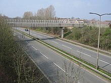
The Splott Junction road looking north

