Abbey Park, Leicester
The park includes the archaeological sites of the Abbey and the ruins of Cavendish House, along with a wide range of decorative and recreational parkland features.
[3] In 1876 Leicester town council bought 57 acres (23 ha) of marshy ground between the river and canal from the Earl of Dysart in order to develop flood prevention plans.
[4] Planning for this first incarnation of the park was underway by 1879, as part of designs by the borough surveyors for the relief of flooding in the area.
[7][8] The works included the widening and deepening of the river over a length of around a mile, with the excavated earth used to create mounds within the park, as well as the construction of stone weirs and locks.
The exact location of the Abbey was unknown, with no standing remains other than the boundary walls and the ruins of the sixteenth century Cavendish House.
[12] After assorted modest excavations, the 32 acre Abbey Grounds site was donated to the city by the Earl of Dysart at the end of 1925.
With the rise in unemployment culminating in the Great Depression the city council attempted to alleviate local poverty by employing a team of workmen to clear pernicious weeds from the overgrown site, and the architect W K Bedingfield was able to utilise this process to also search for, and then uncover the buried foundations of the Abbey buildings.
Having exposed and mapped the extent of the Abbey Church and a variety of monastic buildings, the workforce built low walls to mark out the foundations and pier bases.
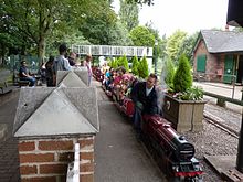
The park now has an area of 89 acres (36 ha),[2] and has formal gardens, a sensory garden, a boating lake and model boat lake, a miniature railway operated by Leicester Society of Model Engineers since 1949, a visitor centre, cafe, children's play area with paddling pool, pets corner, tennis courts, a bowling green,[1] and a bandstand.