Action of 27 February 1941
As Allied forces closed on Massawa, the Italian Red Sea Flotilla was ordered to break out and run for friendly ports.
[1] The Italian squadron managed to evade the British blockade on 20 February and scattered into the Indian Ocean, Ramb I heading for the Dutch East Indies.
[3] Ramb 1 (3,667 gross register tons [GRT]), was 383 ft (117 m) long, 47 ft 11 in (14.61 m) wide at the beam, had a speed of 17 kn (31 km/h; 20 mph) and was a refrigerated merchant ship (reefer) built for the Regia Azienda Monopolio delle Banane (RAMB, the Royal Banana Monopoly Company) in 1933, adapted for naval service as an armed merchant cruiser.
As British, Commonwealth and Imperial troops neared the port, Ramb I and Coburg (7,400 GRT), a German freighter, escaped from Massawa on the night of 20/21 February 1941 and passed into the Gulf of Aden.
[8] Captain Robert Bevan, altered course to the north to head for One and a Half Degree Channel, because news of the capture of Mogadishu in Italian Somaliland (now Somalia) had been received by radio on the previous day.
Leander went to action stations at 11:15 a.m. and when ordered to identify themselves ten minutes later, the crew of the vessel hoisted a British merchant flag.
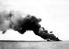
A boat was lowered from Leander with a boarding party to try to save the ship and two lifeboats were seen leaving the vessel as other men jumped overboard or scrambled down the side.
The boarding party laid off and as the fire spread, a big explosion before the bridge shot flames and smoke high into the sky, the ship settling bows first.
The Italian prisoners were transferred to the oiler Pearleaf with an armed guard of nineteen ratings and an officer; the ship made for Colombo, Ceylon (now Sri Lanka).
Leander was sent to investigate indications from wireless direction-finding that Axis ships were in the vicinity of the Saya de Malha Bank, several hundred miles south-east of the Seychelles Islands and north-east of Madagascar.