Actions along the Matanikau
The Matanikau River area includes a peninsula called Point Cruz, the village of Kokumbona, and a series of ridges and ravines stretching inland from the coast.
During the action, three U.S. Marine companies were surrounded by Japanese forces, took heavy losses, and barely escaped with assistance from a U.S. Navy destroyer and landing craft manned by U.S. Coast Guard personnel.
The 17th Army, by this time heavily involved with the Japanese campaign in New Guinea, had only a few units available to send to the southern Solomons area.
After numerous frontal assaults, Kawaguchi's attack was repulsed with heavy losses for the Japanese, who retreated back into the jungle on 14 September.
The 3rd Battalion, 4th (Aoba) Infantry Regiment had landed at Kamimbo Bay on the western end of Guadalcanal on 11 September, too late to join Kawaguchi's attack on the U.S. Marines.
The first operation was assigned to the 1st Battalion, 7th Marine Regiment under Lieutenant Colonel Lewis Burwell "Chesty" Puller with a start date of 23 September.
At the same time, the 1st Raider Battalion—now under the command of Lieutenant Colonel Samuel B. Griffith—was to cross at the mouth of the Matanikau to explore the area between the river, Kokumbona, and further west towards Tassafaronga.
The rest of Oka's force was located west of the Matanikau, but in position to respond quickly to any Allied attacks in that area.
[27] At 17:00 on 24 September, as Puller's men hiked up the northeast slope of Mount Austen, they surprised and killed a bivouac of 16 Japanese soldiers.
Because of resistance by about 100 Japanese defenders around the bridge, the Marines instead proceeded north along the east bank of the Matanikau to the sand spit on the coast at the mouth of the river.
In the meantime, Griffith's Raider battalion—along with Merritt A. Edson, commander of the 5th Marine Regiment—joined Puller and McDougal's troops at the mouth of the Matanikau.
[30] Edson brought with him a "hastily devised" plan of attack—primarily written by Lieutenant Colonel Merrill B. Twining, a member of Vandegrift's division staff—that called for Griffith's Raiders—along with Puller's Company C—to cross the one-log bridge and then outflank the Japanese at the river mouth/sand spit from the south.
If the attacks were successful, the rest of Puller's battalion would land by boat west of Point Cruz to take the Japanese by surprise from the rear.
The Japanese, who had reinforced their units at the mouth of the Matanikau during the night with additional companies from the 124th Infantry Regiment, repulsed the attacks by McDougal's men.
[32][33] As a result of "garbled" messages from Griffith because of a Japanese air raid on Henderson Field that disrupted the Marine communications net, Vandegrift and Edson believed that the Raiders had succeeded in crossing the Matanikau.
apparently in reference to his men trapped on the west side of the Matanikau, and "stormed" off toward the beach where, with the help of his personal signalman, Puller was able to hail the Navy destroyer USS Monssen that was supporting the operation.
Once aboard Monssen, Puller and the destroyer led 10 landing craft towards Point Cruz and established communications with Kelley on the ridge by signal flag.
[43] The Japanese continued to deliver additional forces to Guadalcanal in preparation for their planned major offensive in late October.
Between 1 and 5 October, Tokyo Express runs delivered troops from the 2nd Infantry Division, including their commander, Lieutenant General Masao Maruyama.
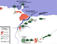
[44] In an attempt to exploit the advantage gained in the September Matanikau action, Maruyama deployed the three battalions of the 4th Infantry Regiment with additional supporting units under Major General Yumio Nasu along the west side of the Matanikau River south of Point Cruz with three companies from the 4th Infantry Regiment placed on the east side of the river.
The Japanese units east of the river were to assist in preparing positions from which heavy artillery could fire into the U.S. Marines' perimeter around Lunga Point.
Meanwhile, the two 7th Marine battalions and the Whaling Group reached positions east of the one-log bridge unopposed and bivouacked for the night.
[49] During the night, the survivors of the Japanese 3rd Company, about 150 men, attempted to break out of their pocket and cross the sandbar at the mouth of the Matanikau.
The 3rd Company soldiers overran two platoons from the 1st Raiders, who were not expecting an attack from that direction, and the resulting hand-to-hand melee left 12 Marines and 59 Japanese dead.
There was yelling, screams of the wounded and dying; rifle firing and machine guns with tracers piercing the night—(a) combination of fog, smoke, and the natural darkness.
The trapped Japanese troops attempted several times to escape by climbing the opposite side of the ravine, only to be cut down in large numbers by massed Marine rifle and machine gun fire.
Having received intelligence information that the Japanese were planning a large surprise offensive somewhere on Guadalcanal, Vandegrift ordered all the Marine units west of the Matanikau to disengage and return to the east side of the river, which was accomplished by the evening of 9 October.
Hyakutake was immediately briefed on the loss of the Japanese positions on the east bank of the Matanikau and the annihilation of one of the 4th Infantry Regiment's battalions.
[53] The Japanese determined that the reestablishment of their forces on the east bank of the Matanikau would be prohibitive in terms of the number of troops required to accomplish it.
Thus, the failure of the Japanese to gain and hold a strong position on the Matanikau proved to have lasting strategic consequences in the battle for Guadalcanal, significantly contributing to the ultimate Allied victory in the campaign.