Air navigation
In the former case, a pilot will largely navigate using "dead reckoning" combined with visual observations (known as pilotage), with reference to appropriate maps.
It also includes sufficient ground detail – towns, roads, wooded areas – to aid visual navigation.
Occasionally, the pilot may elect on one leg to follow a clearly visible feature on the ground such as a railway track, river, highway, or coast.
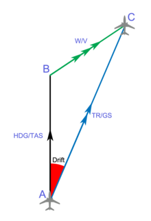
When an aircraft is in flight, it is moving relative to the body of air through which it is flying; therefore maintaining an accurate ground track is not as easy as it might appear, unless there is no wind at all—a very rare occurrence.
Initially the pilot will calculate headings to fly for each leg of the trip prior to departure, using the forecast wind directions and speeds supplied by the meteorological authorities for the purpose.
These figures are generally accurate and updated several times per day, but the unpredictable nature of the weather means that the pilot must be prepared to make further adjustments in flight.
The ETP is not dependent on fuel, but wind, giving a change in ground speed out from, and back to the departure aerodrome.
In Nil wind conditions, the ETP is located halfway between the two aerodromes, but in reality it is shifted depending on the windspeed and direction.
Commercial aircraft are not allowed to operate along a route that is out of range of a suitable place to land if an emergency such as an engine failure occurs.
The ETP calculations serve as a planning strategy, so flight crews always have an 'out' in an emergency event, allowing a safe diversion to their chosen alternate.
Finally, the pilot should have in mind some alternative plans in case the route cannot be flown for some reason – unexpected weather conditions being the most common.
Pilots must also comply with all the rules including their legal ability to use a particular instrument approach depending on how recently they last performed one.
In recent years, strict beacon-to-beacon flight paths have started to be replaced by routes derived through performance-based navigation (PBN) techniques.
When operators develop flight plans for their aircraft, the PBN approach encourages them to assess the overall accuracy, integrity, availability, continuity, and functionality of the aggregate navigation aids present within the applicable airspace.
Once these determinations have been made, the operator develops a route that is the most time and fuel efficient while respecting all applicable safety concerns—thereby maximizing both the aircraft's and the airspace's overall performance capabilities.
This means that the pilot must stick to the calculated headings, heights and speeds as accurately as possible, unless flying under visual flight rules.
The visual pilot must regularly compare the ground with the map, (pilotage) to ensure that the track is being followed although adjustments are generally calculated and planned.
The compass itself will only show a steady reading when the aircraft has been in straight and level flight long enough to allow it to settle.
This is a 'wind-star' maneuver and, with no winds aloft, will place him back on his original track with his trip time increased by the length of one diversion leg.
NDBs also can give erroneous readings because they use very long wavelengths, which are easily bent and reflected by ground features and the atmosphere.
For convenience, some VOR stations also transmit local weather information which the pilot can listen in to, perhaps generated by an Automated Surface Observing System.
From the 1970s airliners used inertial navigation systems, especially on inter-continental routes, until the shooting down of Korean Air Lines Flight 007 in 1983 prompted the US government to make GPS available for civilian use.
GNSS makes navigation precision once reserved to large RNAV-equipped aircraft available to the GA pilot.
This was especially essential when trips were flown over oceans or other large bodies of water, where radio navigation aids were not originally available.