Agriates Desert
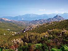
The Agriates Desert is a territory bordered to the south by a mountain range, the Serra di Tenda, and on all other sides by the Mediterranean Sea.
The less rugged eastern sector, made up of ancient granite rocks, has flatter parts that are still home to vineyards—in the 1800s, the Agriates were considered the breadbasket of Corsica.
From east to west, the major ones are: Valdolèse, Santu, Panecalellu, Niolincu, Liscu, Scalavita, Toccone, Scruchiella, Alga, Tettu, Sualelli, and Tafonatu.
Unlike the image many hold of a desert, there is abundant local vegetation adapted to the local climate, including such common maquis plants as strawberry trees, briar root, myrtle spurge, rockrose, linstisques, evergreen oak, and olive trees.
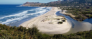
The first, which is 13 km long, starts in Bocca di Vezzu and leads to Malfalcu Cove or to Plage de Ghignu.
In the mid-20th century, tourist development was planned for a large portion of the western Agriates, owned by the Casabianca and Rothschild families.
But the Conservatoire du littoral conservation organization patiently bought up all of the territory's coastline, protecting more than 5,600 hectares and 37 km of coasts.
— Agostino Giustiniani, translated to English from a French translation by the abbot Lucien Auguste Letteron [fr] in Histoire de la Corse Tome I, Description de la Corse - Bastia Imprimerie et librairie Ollagnier - 1890 p. 16In 1584, the island was hit by a famine, and all resources were scarce.
Letterton writes, "The sole cause, or at least the main cause, of the famine that reigned during those sad years must be the abandonment of their rich and opulent villages by the inhabitants of the coast, who, in order to flee the attacks of the barbarians, had withdrawn during the earlier wars to the arid and barren mountains.
The Republic of Genoa, which lacked a sufficiently developed hinterland, also farmed in the Agriates to feed its metropolitan population.
For a long period the land was used from June to October by farmers who came by sea on small boats from Cap Corse (Nonza, Farinole, Centuri) or from Balagne.
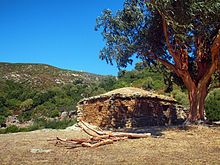
Pagliaghju were dry stone huts, with rounded roofs or terraces, which were used as homes, to hold sheep, or to store wheat, hay, or tools.
Though the structures are long abandoned, some are still in good condition, while others have been restored and converted into tourist rentals, including in Alga Putrica, west of Guignu beach.
Since 1979, 5,532 hectares of the Agriates Desert, representing 37 kilometers of coastline, have been acquired by the Conservatoire du littoral.
[6] Today, the Conservatoire controls a third of the land and the marine area, serving as a long-term guarantor of the natural landscape.
The department of Haute-Corse is responsible for the management of the region, which includes surveillance, maintenance, public access, and development.
In the summer, they contribue to the desert's fire prevention system, warning visitors when the Saleccia trail is closed on high-risk days.
They are also given the power of law enforcement officers and can issue a procès-verbal, enabling them to combat illegal camping, fires, and off-road driving.
There are three sites recognized as second-generation Zone naturelle d'intérêt écologique, faunistique et floristique (ZNIEFF) in the Agriates Desert: The region is designated as part of the Europe-wide Natura 2000 network, registered as FR9400570.