Geography of Hungary
The country secured some boundary revisions from 1938 to 1941: In 1938 the First Vienna Award gave back territory from Czechoslovakia, in 1939 Hungary occupied Carpatho-Ukraine.
In 1940 the Second Vienna Award gave back Northern Transylvania and finally Hungary occupied the Bácska and Muraköz regions during the Invasion of Yugoslavia.
After World War II, the Trianon boundaries were restored with a small revision that benefited Czechoslovakia.
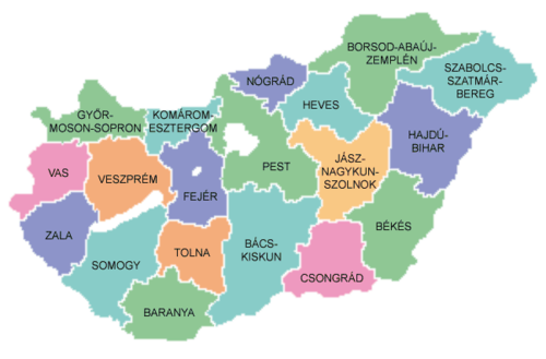
Hungary has three major geographic regions (which are subdivided to seven smaller ones): the Great Alföld, lying east of the Danube River; the Transdanubia, a hilly region lying west of the Danube and extending to the Austrian foothills of the Alps; and the North Hungarian Mountains, which is a mountainous and hilly country beyond the northern boundary of the Great Hungarian Plain.
Hungary lacks extensive domestic sources of energy and raw materials needed for industrial development.
Here is found the puszta, a long, and uncultivated expanse (the most famous such area still in existence is the Hortobágy National Park), with which much Hungarian folklore is associated.
In the last half of the 19th century, the government sponsored programs to control the riverways and expedite inland drainage in the Great Plain.
With the danger of recurrent flooding largely eliminated, much of the land was placed under cultivation, and herding ceased to be a major contributor to the area's economy.
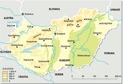
Although the majority of the country has an elevation lesser than 300 m, Hungary has several moderately high ranges of mountains.
Alpokalja (literally the foothills of the Alps) is located along the Austrian border; its highest point is Írott-kő with an elevation of 882 metres.
Mecsek is the southernmost Hungarian mountain range, located north from Pécs - Its highest point is the Zengő with 682 metres.
Minerals are a major resource of the area and have long been the basis of the industrial economies of cities in the region.
Hungary has a mainly continental climate with the rest of the Pannonian Plain, with cold winters and warm to hot summers.
Weather conditions in the Great Plain can be especially harsh, with hot summers, cold winters, and scant rainfall.
The last covers more than half of the country (52,000 km2 in number), whereas soil quality varies extremely; the territory even contains a small, grassy semi-desert, the so-called puszta (steppe in English).
The most important Hungarian agricultural products include corn, wheat, barley, oat, sunflower, poppy, potato, millet, sugar-beet, flax, and many other plants.
There are numerous fruits reared, including many subspecies of apple, pear, peach, grape, apricot, watermelon, cantaloupe, etc.
Viticulture has been recorded in the territory of today's Hungary since the Roman times, who were responsible for the introduction of the cultivation of wines.
Natural hazards: occasional flooding National parks Environment - current issues: The approximation of Hungary's standards in waste management, energy efficiency, and air, soil, and water pollution with environmental requirements for EU accession will require large investments.