Ahr Valley
It begins at the Ahr spring (Ahrquelle) in Blankenheim in the county of Euskirchen (North Rhine-Westphalia) and runs generally eastwards.
Here it is characterized by vineyards on the south-facing slopes and a picturesque rocky landscape, carved out by the river creating a 300 metre deep gorge in the Ahr Hills.
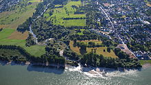
In the next stage the Ahr reaches the area of the county town of Bad Neuenahr-Ahrweiler, before finally discharging into the Rhine south of Remagen in the borough of Sinzig.
[1] From its head, the Ahr valley runs through a rolling uplands with pastures, woods and occasional hamlets or farmsteads.
From here the valley runs through Antweiler to Fuchshofen, almost northwards, before swinging almost due east from Schuld, passing Insul and reaching Dümpelfeld where it is joined by the B 257.
Near Laach the Ahr runs round another loop in the valley and then passes the wine villages of Mayschoß, Rech, Dernau and Marienthal before finally reaching the territory of the town of Bad Neuenahr-Ahrweiler.
The last narrow portion of the Ahr valley lies below the Bunte Kuh ("Coloured Cow"), a rock formation that reaches almost to the river and leaves hardly any room for road and railway.
The valley floor between Bad Bodendorf on the northern edge and Sinzig on a terrace to the south, is characterised by arable farming, fruit and vegetable growing.
Below the vineyards near Marienthal, a concealed government bunker was built in 1962 in a wider section of the valley between Dernau and Bad Neuenahr-Ahrweiler.