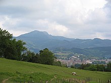
Peñas de Aya
Its characteristic shape can be made out approximately from as far as Bayonne (north), the massif being dubbed the "face of Napoleon" on account of its similar outline, while its actual French name is Les Trois Couronnes.
At its western foot, the mountain holds the site Arditurri related to ancient Oiasso with a network of mine corridors carved in the rock and put down to Romans.
Besides being considered by some the westernmost tip of the Pyrenees (rivalling with the coastal mountain Jaizkibel), it stands out as a distinctive range of rocky prominences and gullies, otherwise uncommon.
Later orogeny pushed a mass of igneous rocks to the surface, so metamorphosing the superficial Paleozoic materials as it tore its way out of them, which yielded the present day granitic landscape.
[1] The materials held by the mountain enticed the Romans to these reaches, who settled in the riverside town of Oiasso with important port and factory vestiges unveiled recently.
The trail falls past the remains of a military defence line dating from the Civil War till an open larch forest is reached, and on to the pass of Elurretxe (road).
In the first option, the trail runs back south at middle height through forest landscape most of the time, except for the final stage, before merging with the starting point in Aritxulegi.
The road winds up for another 15 minutes gaining height gradually until Elurretxe is reached (Km 8, open larch forest and picnic area on the right).
At the western foot of the massif, a pleasing and pretty flat greenway has been arranged for cyclists and pedestrians along the river Oiartzun, which heads east into the wild up to the Arditurri mines.