Aitutaki
[5][6] Satellite image measurement suggests that the larger figure also includes the reef flat, which is commonly not considered part of a lagoon.
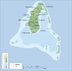
[7] The barrier reef that forms the basis of Aitutaki is roughly the shape of an equilateral triangle with sides 12 kilometres (7.5 mi) in length.
The southern edge of the triangle is almost totally below the surface of the ocean, and the eastern side is composed of a string of small islands including Mangere, Akaiami, and Tekopua.
The western side of the atoll contains many of Aitutaki's important features including a boat passage through the barrier reef allowing for anchorage close to shore at Arutanga.
[3] The first known European contact was with Captain Bligh and the crew of HMS Bounty when they also arrived in Aitutaki on 11 April 1789, prior to the infamous mutiny.
It appears that, though the inhabitants of Aitutaki regarded themselves as British subjects, the Crown's title was uncertain, and the island was formally annexed by Proclamation dated 9 October 1900.
The American engineering firm Sverdrup & Parcel, the New Zealand Ministry of Works, US military personnel and many locals combined to build two airstrips which were completed on 14 November 1942.
During the 1950s Aitutaki's lagoon was used as a stopover for TEAL (Tasman Empire Airways Limited) flying boats on the famous Coral Route.
Commercial banana-growing was introduced to the island in the late 1960s, but suffered a rapid decline due to wind damage, low prices, and inadequate shipping.
The high winds of the storm ripped the roofs off of most houses and damaged other buildings including a school and a hospital.
In September 2020 Aitutaki was connected to the Manatua One Polynesia Fibre Cable, becoming one of the smallest fibre-connected islands in the world.
[28] Since 2000 Aitutaki has served as a filming location for a variety of TV shows, including Shipwrecked,[29][30] Survivor: Cook Islands,[31] and Survivorman.
[32] The flora of Aitutaki is highly modified, and on the main island only a few patches of degraded native forest survive near the airstrip.
The inland plateau is extensively cultivated, with plantations of coconuts, banana, citrus, and other food plants, as well as assorted introduced decorative shrubs.
[34] The high ground on the island was cleared during World War 2 for military installations and now consists of grasses and weedy species.
[38] Subfossil remains show that Kuhl's lorikeet, the spotless crake, and an undescribed species of whistling duck were all at one stage extant on Aitutaki before being extirpated.
[33] The main island has been designated an Important Bird Area (IBA) by BirdLife International because it supports a population of blue lorikeets.
It is regarded as providing the visitor with the best views of the Aitutaki lagoon and, depending on the tide, one is able to walk on a sandbank a decent distance away from Tapuaetai.
The main island is equally divided among the three constituencies Arutanga-Reureu-Nikaupara (southwest), Vaipae-Tautu (southeast), and Amuri-Ureia (north).