Lajjun
The Israeli kibbutz of Megiddo, Israel was built 600 metres north-east of the depopulated village on the hill called Dhahrat ed Dar from 1949.
Named after an early Roman legion camp in Syria Palaestina province called "Legio", predating the village at that location, Lajjun's history of habitation spanned some 2,000 years.
Modern Lajjun was built on the slopes of three hills, roughly 135–175 meters above sea level,[6] located on the southwestern edge of the Jezreel Valley (Marj ibn Amer).
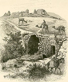
That section is called Wadi es-Sitt (valley of the lady) in Arabic,[7] The northern quarter was built in close proximity to a number of springs, including 'Ayn al Khalil, 'Ayn Nasir, 'Ayn Sitt Leila, and 'Ayn Jumma, collectively known as 'Uyun Seil Lajjun.
[5] During the rule of the Canaanites and then the Israelites, Megiddo, located on the military road leading from Asia to Egypt and in a commanding situation, was heavily fortified by both peoples.
Lajjun stream has been identified with the brook Kina, or Qina, which is mentioned in the Egyptian descriptions of Thutmose III's Battle of Megiddo.
[22][23] It appears in Latin characters under its old name Caporcotani in the Tabula Peutingeriana Map, and lay along the Roman road from Caesarea to Scythopolis (Beit Shean).
In 2001 and 2004, the Israel Antiquities Authority conducted archaeological excavations at Kefar ‘Otnay and Legio west of Megiddo Junction, recovering artifacts from the Roman and early Byzantine periods.
[32] According to medieval geographers Estakhri and Ibn Hawqal, Lajjun was the northernmost town of Jund Filastin (military district of Palestine).
[13] The Jerusalemite geographer, al-Muqaddasi, wrote in 985 that Lajjun was "a city on the frontier of Palestine, and in the mountain country ... it is well situated and is a pleasant place".
[39][40] When the Crusaders invaded and conquered the Levant from the Fatimids in 1099, al-Lajjun's Roman name, Legio, was restored and the town formed a part of the lordship of Caesarea.
In 1182, the Ayyubids raided Legio, and in 1187, it was captured by them under the leadership of Saladin's nephew Husam ad-Din 'Amr and consequently its Arabic name, Lajjun, was restored.
[5] In 1226, Arab geographer Yaqut al-Hamawi writes of the Mosque of Abraham in Lajjun, the town's "copious stream", and that it was a "part of the Jordan Province".
[41] A number of Muslim kings and prominent persons passed through the village, including Ayyubid sultan al-Kamil, who gave his daughter 'Ashura' in marriage to his nephew while visiting the town in 1231.
[44] Shams al-Din al-'Uthmani, writing probably in the 1370s, reported it was the seat of Marj ibn Amer, and had a great khan for travellers, a "terrace of the sultan" and the Maqam (shrine) of Abraham.
As the army of Sultan Selim I moved south towards Egypt,[46] Tarabay ibn Qaraja, chieftain of the Bani Hareth, a Bedouin tribe from the Hejaz, supported them by contributing guides and scouts.
[48][49][50] It was composed of four nahiyas ("sub-districts") (Jinin, Sahel Atlit, Sa'ra, and Shafa), and encompassed a total of 55 villages, including Haifa, Jenin, and Baysan.
[46] In 1596, Lajjun was a part of the nahiya of Sha'ra and paid taxes on a number of crops, including wheat, barley, as well as goats, beehives and water buffaloes.
Ahmad, known for his courage and hospitality,[46] helped the Ottomans defeat the rebel Ali Janbulad and gave shelter to Yusuf Sayfa—Janbulad's principal rival.
He was succeeded by Ahmad's brother Muhammad Tarabay, who—according to his French secretary—had good intentions for governing Lajjun, but was addicted to opium and as a result had been a weak leader.
[47] The main reason behind the Ottoman abandonment of the Tarabays was that their larger tribe, the Bani Hareth, migrated east of Lajjun to the eastern banks of the Jordan River.
[58] Zahir al-Umar, who became the effective ruler of the Galilee for a short period during the second half of the 18th century, was reported to have used cannons against Lajjun in the course of his campaign between 1771–1773 to capture Nablus.
[74] Taken more broadly, Lajjun was one of the settlements of the so-called "Fahmawi Commonwealth", a network of interspersed communities connected by ties of kinship, and socially, economically and politically affiliated with Umm al Fahm.
[76] During 1940–1941, a police station belonging to the Tegart forts system was constructed at the road intersection outside Lajjun by the British Mandate government.
[9] There was a small market place in the village, as well as six grain mills (powered by the numerous springs and wadis in the vicinity), and a health center.
ALA commander Fawzi al-Qawuqji claimed Jewish forces ("Haganah") had attempted to reach the crossroads at Lajjun in an outflanking operation, but the attack failed.
[13] Lajjun was used as transit place by the Israel Defense Forces to transfer 1,400 Arab women, children and elderly from Ijzim, who then were sent on foot to Jenin.
[94] Lajjun is among the Palestinian villages for which commemorative Marches of Return have taken place, typically as part of Nakba Day, such as the demonstrations organized by the Association for the Defence of the Rights of the Internally Displaced.
[95] In 2013, architect Shadi Habib Allah presented a proposal for a Palestinian village to be rebuilt on Lajjun in areas that are currently a park and inhabited by descendants of its displaced residents.
[75] Local tradition centered on 'Ayn al-Hajja, the spring of Lajjun, date back to the 10th century CE when the village was under Islamic rule.