Albufera Natural Park
The park covers an area of 21,120 hectares, including the Albufera wetlands and the coastal zone adjacent to both,[3] and it is located approximately 10 kilometers to the south of Valencia.
On October 23, 1990, the Special Protection Plan document for the Natural Park was approved (subsequently overturned by the Supreme Court of Spain).
[6] In 1902, the Valencian writer Vicente Blasco Ibáñez published the novel Cañas y barro, which is set in the Albufera region at the beginning of the 20th century.
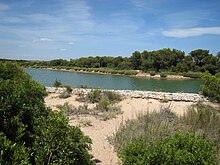
It is separated from the sea by a narrow sandy coastal bar, known as a restinga, which is stabilized by a pine forest, specifically the Dehesa de Saler.
The network of acequias that run through the rice fields also collect water from the springs that emerge from the bottom and the surrounding areas of the lagoon.
Next to them is the lake of the mother-of-pearl (the Albufera), and in the middle of it rises a small island (the Montaña de los Santos) that produces olive trees.
[14]During the Islamic period in the Peninsula, the Emir of Zaragoza, Mostahim, was granted the Albufera as a reward for his alliance with El Cid in the capture of Valencia.
The practice of fishing was formally recognized by the governing authorities in the year 1250, when a group of individuals from the town of Ruzafa (present-day Valencia) relocated to the island of El Palmar and established a permanent settlement there.
King Jaime I was so impressed by this development that he decreed that, "despite being considered external to the kingdom and beyond the city of Valencia's boundaries, they would be permitted to remain attached to the prince's estate".
In 1911, the city of Valencia acquired ownership of both the lake and the Dehesa, thus conferring upon all Valencians the status of proprietors of this natural area of considerable ecological, environmental, and landscape value.
[18] The Dehesa del Saler, located in the wide area between the mouths of the rivers Turia and Júcar, is part of the primitive foreland that caused the closure of the Albufera of Valencia.
A significant element influencing the evolution of the coastline is the longshore drift, which predominantly follows a north–south trajectory and is sufficiently strong to transport sediments carried by rivers.
The two sets of dunes are interspersed with occasional depressions, which are distinguished by their poorly permeable soils and the proximity of the water table to the surface.
The malladas and salt marshes have been subjected to anthropic degradation processes, including silting, desiccation and drainage, which have had a considerable impact on their condition.
Despite the anthropized nature of the environment and the intensive exploitation to which the rice fields are subject, they constitute an essential habitat for the functioning of the Albufera's ecological system and a traditional economic activity of the region's population.
These springs are home to native fauna such as the Spanish toothcarp and the Valencian samaruc, as well as aquatic, marsh and riverside vegetation.
In this regard, the main values of the ullals are the presence of invertebrates endemic to the park, a freshwater aquatic vegetation of the most well-preserved in the peninsula, the habitat of several endangered fish and the primary source of clean water that drains into the lake.
It is the largest in the country, separated from the sea by dunes formed by the roots of a series of pine trees adapted to this situation, and a great abundance of low scrub.
During the season of favourable weather, the various associations of Vela Latina, including Catarroja, El Palmar, Silla and Sollana, offer sailing exhibitions on Saturdays.
The volume of the lake has been reduced to approximately one-third of its 19th-century size, a period during which it extended as far as Valencia, known as Cruz de la Conquista, and further to Sueca, reaching a point referred to as Montanyeta dels Sants.
Pérez Escrich's observations in 1930 recorded a circumference of 9 leagues.This facilitated efficient communication between the various towns and the capital, with regular transport services.
In 1909, Emilio Sarzo, in his book on fishing, the Albufera and metal fabrication, wrote that the depth was very uneven, with water plants very close to the surface in some places and 3 or 4 fathoms deep in others.
El Monte is an island of arboreal vegetation of singular beauty in the middle of the homogeneous plain of the marshes, standing out on the horizon from any corner of the park.
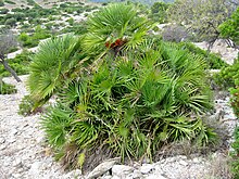
The Maquis and the Mediterranean forest is made up of tree and shrub species such as Baltic pine, French tamarisk, mastic, cade juniper and kermes oak, as well as myrtle, thyme, gorse, rosemary, Micromeria graeca and European fan palm.
Marsh communities have developed, always in contact with the Albufera lake and the various canals and acequias, where reeds, bulrushes, sedges and beach grasses predominate, taking root in the fresh water or in the wet mud.
These reserves are also trying to recover other organisms, the white water lily, the utricularia australis (a carnivorous plant), the marsilea quadrifolia, the purple loosestrife, etc.
The area between Grao de Valencia and Cullera was so rich that, according to the Valencian botanist Cavanilles and other chroniclers of different eras, there was an abundance of deer, wild boars, mountain goats, francolins, partridges, hares, rabbits, otters and up to sixty species of waterfowl, as well as an enormous quantity of fish.
Due to the over-exploitation and pollution of the waters, and the inadequate regulation of the Pujol floodgates, which prevent the natural exchange of species with the sea, only the striped bass remains in the fishery today.
In the Albufera, the cultivation of rice has been banned and authorized several times since the 15th century, because the need for large areas of stagnant water was a dangerous source of infection for the population.
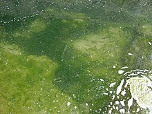
The Albufera, like all wetlands, is a very sensitive area seriously affected by various problems such as water pollution,[25] disturbance of the hydrological regime (especially in relation to the springs), siltation of the marshes, urbanization in the dune system, industrial pressure around the park (especially in the municipalities of Horta Sud and the city of Valencia), the negative impact of various infrastructures such as roads or the port of Valencia, as well as the increase in tourist and recreational pressure.