Aller (Germany)
The river's name, which was recorded in 781 as Alera, in 803 as Elera, in 1096 as Alara, has two possible derivations: The Aller rises in the state of Saxony-Anhalt in the west of the region known as the Magdeburg Börde near Seehausen and north of Oschersleben (Bode).
Initially, the Aller flows rather like a canalised brook in a northwestern direction through low hills and intensively farmed arable fields.
After crossing the state border between Saxony-Anhalt and Lower Saxony, the Aller bends sharply southwest near Grafhorst.
Between here and its mouth, 150 kilometres (93 mi) away, its elevation drops by only about 40 metres (130 ft), so that the speed of the current is considerably reduced in Lower Saxony.
The section of the river known as the Lower Aller (Unteraller) begins at Celle and runs for 120 kilometres (75 mi) to the Weser.
About 4 kilometres (2.5 mi) northwest of the town, near Eißel, a village in the borough of Verden, the Aller finally discharges into the Weser.
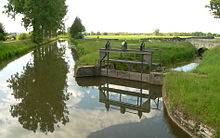
The Aller depression there comprises valley floors lying close to the watertable, so that fertile wet areas may be found here with rich habitats for flora and fauna.
It has the following tributary streams: From the left, the following small rivers and brooks feed the Aller: the Alpe and the Wölpe near Rethem, the Lehrde near Kirchlinteln-Hohenaverbergen, the Gohbach near Verden-Eitze and, just before its mouth, the Halse near Verden-Dauelsen.
The Aller flows gently through relatively natural surroundings alongside meadows and woods, small villages and country towns.
As a result, it is of great importance for those seeking relaxation in Lower Saxony with almost 4 million people in the conurbation of the Hanover-Brunswick-Göttingen-Wolfsburg Metropolitan Region.
The Aller Cycle Way, which is around 250 kilometres (160 mi) long and generally follows the course of the river at some distance, is just one of the leisure attractions in the area.
Since the commissioning of the dams in the Harz, it is now possible to limit the impact, especially of seasonal floods, e.g. by delaying and slowing down the release of meltwaters on the Oker and Ecker, the Innerste and the Grane in spring.
Direct sunlight on much of the river encourages the growth of aquatic plants and, in the absence of shady trees along its banks, the water becomes quite warm during the summer months.
Harz rivers, such as the Aller tributary of the Oker, picked up heavy metals from the mines and their spoil heaps.
Biological water quality, based on the research into its saprobian systems, is generally rated as unpolluted to very lightly polluted.
In the upper courses the Aller filled the flat, swampy basin of the Drömling from which the water drained only slowly.
The Prussian king, Frederick the Great, had the Prussian-owned eastern part of the Drömling drained between 1780 and 1796 and cleared for settlers (Kolonisten).
His neighbours in western Drömling, in the shape of the Duchy of Brunswick and Hanover did not join the drainage project and only began to drain and control the Aller from 1860 onwards.
The flooded areas in the Aller valley varied between 300 and 5,000 metres (980 and 16,400 ft) wide, mainly due to the uneven flow of the river.
[7] The planned 12.5-square-kilometre (4.8 sq mi) "Fahle Heide" basin west of Gifhorn was never built due to lack of funding.
Only two years later, it was determined that these first interventions of the river system had resulted in sand being permanently deposited in the Aller producing shoals.
Ledges (Sohlabstürze) were built on the river bed to reduce erosion; these have since been converted to rock ramps (Sohlgleiten) in order to enable water organisms to pass more easily.
It contributed to the economic growth of Brunswick, because the control of river transport fell into the hands of Duke Henry the Lion.
The Oldau branch is responsible for the Aller from Celle to Hülsen [de ; nl ] 94.1 kilometres (58.5 mi) further downstream.
In contrast, the Verden branch covers the river from Hülsen to its confluence with the Weser near Verden-Eissel 117.1 kilometres (72.8 mi) downstream from Celle.
A major rafting operation took place on the Aller in 1680 when a large quantity of construction wood was floated down to the Weser and its mouth.
The wood came from the southern Lüneburg Heath and was used to build around 100 houses in the Swedish fort of Carlsburg on the site of present-day Bremerhaven.
After the death of George William, Duke of Brunswick-Lüneburg in 1705, timber rafting on the Upper Aller to Celle fell into decline.
In upgrading the Aller between Celle and the mouth of the Leine near Schwarmstedt between 1908 and 1918, hydropower stations were built at two of the four new barrages: Oldau and Marklendorf.
Whilst the structure in Marklendorf was demolished, the power station in Oldau was declared a technological monument and escaped destruction.