Allgäu Alps
The river Lech forms the boundary here from where it leaves the Alps and enters the Alpine Foreland near Füssen upstream to its confluence with the Krumbach near Warth (Vorarlberg).
The border of the Allgäu Alps in the west, where it transitions to the Bregenz Forest Mountains is not orographically distinct.
The Alpine Club classification of the Eastern Alps, published in 1984, draws the boundary as follows: from Au-Rehmen along the Rehmerbach upstream to the Stogger Saddle.
Then it descends, following the Osterguntenbach, the Schönenbach and the Subersach to its confluence with the Bregenzer Ach and along this river to where it joins the Weißach or event to Lake Constance.
It then continues along the Konstanzer Ache and the Großer Alpsee lake to Immenstadt and onwards through the villages of Rettenberg, Wertach, Nesselwang to Pfronten-Ried.
If these ridges are counted as part of the Allgäu Alps, then the northern boundary runs from Lake Constance near Lindau to Isny and northwards around the Adelegg to Kempten.
The only mountain chain proper runs through the south-eastern and eastern part of the Allgäu Alps and forms the Austro-German border.
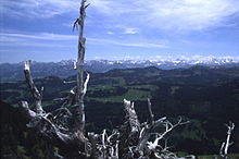
The main chain of the Allgäu Alps is not in the middle of the mountain range, but on its southern and south-eastern perimeter.
It is, for example, only 3.5 km as the crow flies from the summit of the Hohes Licht to the Lech valley road to the south.
Despite these clear factors, hikers still approach the Allgäu Alps, including their main chain, predominantly from the north, i.e. from the German side.
From the Fellhorn to the Widderstein, there is a ridge in front of the main chain, which terminates in a semicircle at the head of the Kleines Walsertal valley.
The mountain chain character of the Allgäu Alps is interrupted by the Ifen and the Gottesacker Plateau (Cretaceous rocks).
This accounts for the isolated location of these mountains which are not topographically connected to the main chain of the Allgäu Alps.
The current, 16th edition, of the Alpine Club Guide for the Allgäu Alps adopts a coarser division into only twelve subgroups.
The Besler, like many other mountains of this subrange, offers a good view of the main chain of the Allgäu Alps.
Thus the Hohe Ifen and the Gottesacker plateau form a geological window through which the next oldest rock below the flysch layer (Flyschdecke) comes to light.
However, there are also isolated areas such as the Himmelschrofen ridge and Peischel Group which lies to the south alongside the Lech Valley.
And finally, there are the Schratten limestones of the Cretaceous period on the Grünten, making it a geological relative of the Hoher Ifen.
Whilst large areas of the Allgäu Alps are made of brittle main dolomite or Jurassic rocks of the Allgäu Beds which must also be carefully handled, Wetterstein limestone, a reef limestone, dominates the main part of the Tannheim Mountains.
As a result, the Tannheim Mountains, with their well known peaks, the Rote Flüh, Gimpel, Köllenspitze and Gehrenspitze, are a renowned climbing area.
The Höfats and Rauheck Group cover that part of the Allgäu main chain between the Märzle and Hornbachjoch saddles.
The highest peak is the Rauheck, 2,384 m. The steep grass mountains of lias rock dominate here more than in any other subgroup of the Allgäu Alps.
The Hochvogel, with its main base, the Prinz Luitpold Haus, is also the most climbed mountain in this sub-range by a long chalk.
To the east runs the long valley of the Schwarzwasser from the foot of the Sattelköpfe and which empties into the Lech south of Weißenbach and should not be confused with its better known counterpart in the Kleinwalsertal.
A walk on the Jubilee Trail between the Willersalpe and Prinz Luitpold Haus takes the visitor along a mountain path at considerable height along most of the chain.
The Tyrolean portion largely comprises the Lech river and its tributaries and the Vorarlberg part centres on the catchment area of Bregenzer Ach.
Looking at the Allgäu Alps in a wider sense, including the Adelegg, the German federal state of Baden-Württemberg also has share.
Although the Kleines Walsertal has a relatively long border with the rest of Vorarlberg, high mountains have prevented a road connection being built.
Those marked with an asterisk (*) are outside the narrower definition of the Allgäu Alps (see Boundary section): The following are the so-called "grass mountains" (Grasberge), made from rocks of the Black Jurassic, whose mountainsides have gradients of up to 70°.
They are the distinguishing feature of the Allgäu Alps and are not found in any other mountain group as prominently as they are here (listed in alphabetical order).