Allston
Allston is bordered on the east and north by the Charles River, and the Cambridge, Massachusetts is accessible via several bridges.
[2] Lower Allston is a small neighborhood that consists of a mix of young professionals, blue-collar tradesmen, members of the educational community, homeowners, and long-term residents.
The neighborhood is very quiet, has extremely low crime,[citation needed] and is an easy walk to Allston Village or Harvard Square.
[3] Lower Allston has close proximity to Route 2, the Mass Pike, Storrow Drive, and Soldiers Field Road.
[4] In the early 21st century, Harvard University announced dramatic expansion plans that called for major building projects, including the demolition of existing businesses, to prepare for the construction of new biology and science buildings in the northern sections of Lower Allston.
[5] While the existing building stock was demolished and businesses were evicted, the financial crisis of 2008 and the resultant decrease in Harvard's endowment caused the university to suspend the expansion projects.
The Massachusetts Turnpike Extension, built largely on part of the Boston and Albany right-of-way, opened through Allston in 1964 and 1965.
Brighton Avenue, between Packard's Corner and Allston Street, boasts various ethnic and national cuisines from around the world.
This synchronized mass movement also makes it difficult to rent large vehicles during the weeks surrounding September 1.
The renters who are leaving often put their unwanted possessions out in the streets for those who may want the items, which include bedding, couches, tables, kitchenware, and clothing.
Unsalvaged items also contribute to unusually large trash and recycling pickups scheduled around the time.
[citation needed] In the 1960s, Boston Mayor Kevin White developed Summerthing, a series of free concerts performed at Allston's Ringer Park.
Several Rock and Roll Hall of Fame artists played for free, including The Byrds, Bo Diddley, BB King and Chuck Berry.
Jackson Mann School, also on Armington Street, serves residents from kindergarten through eighth grade.
[citation needed] Boston University lies along Commonwealth Avenue to the east, with numerous schools and facilities extending from Kenmore Square to Packard's Corner.
The New Balance Field of Boston University symbolizes further integration of BU into the Allston community and is the first in a series of projects that have included the creation of a major new dormitory building in the area.
[citation needed] The B branch of the Boston MBTA subway Green Line runs through the neighborhood along Commonwealth Avenue.
Until 2013, the CSX Railroad operated the large Beacon Park freight yard which runs adjacent to the Massachusetts Turnpike; the land has been purchased by Harvard.
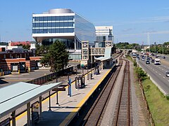
[34] In June 2012, plans were announced for a station to be called Boston Landing, located in Brighton, to serve the Allston-Brighton area.
The station's construction will coincide with a plan to straighten the Massachusetts Turnpike over the former CSX rail yard.
[citation needed] Young adults (age 18-34) make up 80.8% of the neighborhood's population (as compared to 39.1% for the city of Boston as a whole).
In addition to nightly dancing and live music at area bars, house parties abound on surrounding streets, particularly during the school year.