Altenburg
It is the capital of the Altenburger Land district and part of a polycentric old-industrial textile and metal production region between Gera, Zwickau and Chemnitz with more than 1 million inhabitants, while the city itself has a population of 33,000.
Altenburg was first mentioned in 976 and later became one of the first German cities within former Slavic area, east of the Saale river (as part of the medieval Ostsiedlung movement).
Economic malaise set in while Altenburg was in East Germany and continued after German reunification in 1990, evidenced by a decline in population, high unemployment and house vacancy rates.
Altenburg lies in the flat and fertile landscape of Osterland on the Pleiße river in the very east of Thuringia, next to the neighboring federal state of Saxony.
The town's location on the imperial road 'Via Imperii' between Halle and Cheb in Bohemia gave Altenburg economic importance in the salt trade.
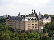
The first castle, located under the present day church St. Bartholomäi, was destroyed after the Battle of Hohenmölsen between Henry IV and Rudolph of Swabia.
The castle later became an imperial palatinate and played an important part in the German takeover and settlement of the area between the Harz-mountains and the Elbe.
Together with the Royal forests Leina, Pahna, Kammerforst and Luckauer Forst, lands of the Groitzsch family bought by Frederick Barbarossa, Altenburg, Colditz, Zwickau and Chemnitz were turned into the Terra Plisnensis.
During the Interregnum, the Terra Plisnensis was impounded, but bought back by Rudolph I of Germany, who desired the crown of Thuringia.
Altenburg was a working-class city during the Weimar Republic, ruled by SPD and KPD, which led to heavy conflicts between left- and right-wing forces after 1933.
Altenburg is located on the southern edge of the Leipzig Bay, a flat and fertile area, with intensive agricultural use and lignite surface mining 10 km (6 mi) north of the town.
The elevation of the city center is 200 m, to the north it declines down to 162 m and in the south next to Mockzig district it rises up to 261 m. Altenburg is bounded by Windischleuba, Nobitz, Altkirchen, Göhren, Lödla, Rositz, Meuselwitz, Treben and Gerstenberg.
Because of the quite densely settlement of the region, many small villages and ancient former suburbs are situated within the municipal territory, which is officially divided into 4 districts: For a detailed view of Altenburg's administrative division, see the list in German Wikipedia.
During the Middle Ages, it had a population of 3,000 to 4,000 inhabitants, rising to 6,000 around 1700, 10,000 around 1800 and 20,000 around 1870, making it Thuringia's second-largest city after Erfurt for a short time in the mid-19th century.
It occurred after the reunification for a short time in the 1990s, but most of the suburban areas were situated within the administrative city borders, others are Windischleuba and Nobitz.
During the 1990s and the 2000s, many inhabitants left Altenburg to search a better life in western Germany or other major east German cities like Leipzig, Dresden or Jena.
The birth deficit, caused by the high average age of the population, is becoming a bigger problem because there is no immigration to compensate it.
Despite urban planning activities to tear down unused flats, vacancy is still a problem with rates around 16% (according to 2011 EU census), which is the largest amount among Thuringia's major towns.
[5] The most important target regions of Altenburg migrants are the large cities around like Leipzig, Dresden, Halle, Jena and Erfurt, as well as the western German conurbations.
The area around the castle and southward on the eastern bank of Blaue Flut river has also been urban since the Middle Ages, nevertheless, it was located outside the city walls.
During the 19th and early 20th century, Altenburg saw a construction boom and the town enlarged to all directions, particularly north and east towards the new railway station (opened in 1878).
Nevertheless, the buildings' maintenance was neglected during the East German period, instead, some big Plattenbau settlements were set up on the northern and south-eastern periphery of Altenburg.
A famous product of the region is Altenburger Ziegenkäse, a soft cheese of goat milk with some caraway seed inside with protected Geographical indication.
The industry of Altenburg was based on the production of textiles and hardware during the 19th and 20th century, but most of the companies did not survive the transition to capitalism after German reunification.
Today, the main branches are food industries (with a factory of Vion NV amongst others) and engineering with car component production in focus.
The Altenburger Spielkartenfabrik (playing card factory) was founded in 1831; today it is a subsidiary company of Cartamundi and market leader in Germany.
Tourism doesn't play a big role, although the city hosts many historic sights and is a local center of culture with theater and museums.
The first freely elected mayor after German reunification was Johannes Ungvari of the Christian Democratic Union (CDU), who served from 1990 to 2000.