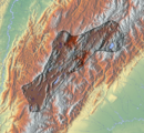
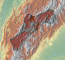
Altiplano Cundiboyacense
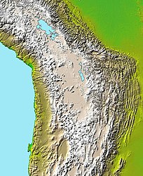
The Altiplano Cundiboyacense (Spanish pronunciation: [altiˈplano kundiβoʝaˈsense]) is a high plateau located in the Eastern Cordillera of the Colombian Andes covering parts of the departments of Cundinamarca and Boyacá.
From the Early Cretaceous until the Eocene, the region of the present-day Altiplano was dominated by a marine environment, as part of the long inland sea of northern South America.
In these warm tropical seas a fauna of ichthyosaurs and pliosaurs developed, with important finds (Kronosaurus boyacensis (El Fósil), Muiscasaurus, with four nostrils) in the Paja Formation of Villa de Leyva.
[5] During the Late Eocene-Early Oligocene (35-30 Mya) epochs, South America became detached from its longest connected former member of Pangea; Antarctica.
[8] In the earliest ages of human population prehistoric animals as the Cuvieronius, Haplomastodon and Equus amerhippus were living on the Altiplano.
[9] Later dated excavations have revealed a transition from a hunter-gatherer society living in rock shelters to open area settlements with Checua and Aguazuque as examples.
[10] During the earliest phases, the first humans lived together with Pleistocene now extinct mastodons, as the fossil remains of Haplomastodon waringi, Neochoerus and Odocoileus in Soatá indicate.
Other mammals included little red brocket (Mazama rufina), guinea pigs (Cavia porcellus), nine-banded armadillo (Dasypus novemcinctus), white-lipped peccary (Tayassu pecari), crab-eating fox (Dusicyon thous), spectacled bear (Tremarctos ornatus), ocelot (Felis pardalis), puma (Felis concolor), lowland paca (Agouti paca), Agouti taczamawskii, Dasyprocta, ring-tailed coati (Nasua nasua), western mountain coati (Nasuella olivacea), common opossum (Didelphis marsupialis) and collared anteater (Tamandua tetradactyla).
[12] Various archaeological sites with petroglyphs or pictographs have been discovered on the Altiplano Cundiboyacense, among others in Bojacá, Bogotá, Chía, Usme, Cogua, Cota, Facatativá, Nemocón, Madrid, Mosquera, Sáchica, Sibaté, Soacha, Subachoque, Suesca, Sutatausa, Tenjo, Tocancipá, Zipacón, Zipaquirá.
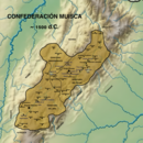
The leaders of the Confederation at the time of conquest were zipa Tisquesusa, zaque Quemuenchatocha, iraca Sugamuxi and Tundama in the northernmost portion of their territories.
For the main part self-sufficient in their well-organised economy, the Muisca traded with the European conquistadors valuable products as gold, tumbaga (a copper-silver-gold alloy) and emeralds with their neighbouring indigenous groups.
In the Tenza Valley, to the east of the Altiplano Cundiboyacense where the majority of the Muisca lived, they extracted emeralds in Chivor and Somondoco.
The economy of the Muisca was rooted in their agriculture with main products maize, yuca, potatoes and various other cultivations elaborated on elevated fields (in their language called tá).
[17] The cacicazgos were self-sufficient in their agricultural products and surpluses of maize (abitago) were traded for more tropical climate fruits such as pineapples, avocados and Ipomea batatas.
[21][22] A delegation of more than 900 men left the tropical city of Santa Marta in April 1536 and went on a harsh expedition through the heartlands of Colombia in search of El Dorado and the civilisation that produced all that precious gold.
The towns of Moniquirá (Boyacá) and Guachetá and Lenguazaque (Cundinamarca) were founded before the conquistadors arrived at the northern edge of the Bogotá savanna in Suesca.
That same month, on August 20, the zipa who succeeded his brother Tisquesusa upon his death; Sagipa, allied with the Spanish to fight the Panche, eternal enemies of the Muisca in the southwest.
Two other expeditions that were taking place at the same time; of De Belalcázar from the south and Federmann from the east, reached the newly founded capital and the three leaders embarked in May 1539 on a ship on the Magdalena River that took them to Cartagena and from there back to Spain.
Gonzalo Jiménez de Quesada had installed his younger brother Hernán as new governor of Bogotá and the latter organised new conquest campaigns in search of El Dorado during the second half of 1539 and 1540.

• Duitama-Sogamoso Iraca Valley
• Ubaté-Chiquinquirá Valley
• Bogotá savanna