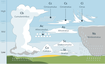
Altostratus cloud
Altostratus is a middle-altitude cloud genus made up of water droplets, ice crystals, or a mixture of the two.
Altostratus clouds are formed when large masses of warm, moist air rise, causing water vapor to condense.
Altostratus clouds are usually gray or blueish featureless sheets, although some variants have wavy or banded bases.
Once altostratus clouds associated with a warm front arrive, continuous rain or snow will usually follow in the next 12 to 24 hours.
Although altostratus clouds predict the arrival of warmer, wetter weather, they themselves do not produce significant precipitation.
Because altostratus clouds can contain ice crystals, they can produce some optical phenomena like iridescence and coronas.
Altostratus clouds are generally gray or blue-tinged with a largely-uniform blanket-like appearance.
[3] While they do not produce significant precipitation, altostratus clouds can cause light sprinkles or even small rain showers.
[6] However, they still appear in five varieties: Altostratus duplicatus, opacus, radiatus, translucidus, and undulatus.
[19] Higher lapse rates (i.e. the faster temperature drops with increasing altitude) were associated with colder clouds.
[18] The average temperature of altostratus clouds, based on data collected from roughly 45° to 80° latitude, varied from around −16 to −45 °C (3.2 to −49 °F).
[21] In some altostratus clouds made of ice crystals, very thin horizontal sheets of water droplets can appear seemingly at random, but they quickly disappear.
[22] The sizes of the ice crystals in the cloud tended to increase as altitude decreased.
These water droplets are spheres and thus fall much faster than ice crystals, collecting at the bottom of the cloud.
[25] Altostratus clouds form when a large mass of warm air rises, causing water vapor in the atmosphere to condense onto nuclei (small dust particles), forming water droplets and ice crystals.
[27] Altostratus can even form from the spreading of the upper anvil cloud or the middle column of a thunderstorm.
In temperate regions, the ceiling increases drastically, allowing altostratus clouds to form between 2,000 to 7,000 metres (6,600 to 23,000 ft).
[3] They can range from 1,000 to 5,000 metres (3,300 to 16,000 ft) in thickness[3] and can cover hundreds of kilometers of the Earth's surface.
[36] Halos can take the appearance of rings, arcs, or spots of white or multicolored light and are formed by the reflection and refraction of sunlight or moonlight shining through ice crystals in the cloud.
[4][39][40] Cirrocumulus and cirrostratus are sometimes informally referred to as cirriform clouds because of their frequent association with cirrus.
These are sometimes classified separately as clouds of vertical development, especially when their tops are high enough to be composed of supercooled water droplets or ice crystals.