Altstadt (Munich)
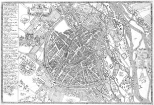
The sloping edge runs along the west side of Oberanger, Rosental, Viktualienmarkt,[3] Sparkassenstraße and Marstallplatz and separates the upper from the lower Hofgarten (courtyard garden).
Descriptively, the term has been used since the 19th century to distinguish the historic center, that within the original city walls of the newly created suburbs.
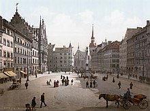
In the center of the Old Town is the Marienplatz which is where the traditional history of Munich began with the founding of a market on 14 June 1158 in Augsburger Schied (arbitration) by Henry the Lion.
The New Town Hall on Marienplatz, a demonstration of urban independence, dates back to the end of the 19th century.
Reconstruction was carried out with extensive preservation of the medieval streets and most of the cityscape influential large buildings such as the churches, the residences, the National Theater, the Alter Hof (Old Court), the city gates, to the state as they were before the war, and the Old and New Town Hall.
[9] The bourgeois buildings of the Old Town of Munich, as documented by the photographs of Georg Pettendorfer, were largely lost.
The border between the inner and outer city ran along the streets of Sparkassenstraße, Viktualienmarkt, Rosental, Färbergraben, Augustinerstraße, Schäfflerstraße, Schrammerstraße and Hofgraben.
More important than the distinction between the inner and outer city was, the still existing division of the Old Town into districts in the Middle Ages, which were separated by the main traffic axes of Munich.
[11] The council protocol of 29 December 1458, designated three of the districts for the first time with today's names: the Hackenviertel, the Kreuzviertel and the Graggenauer Viertel.
The first quarter was still called Rindermarktviertel, the name Angerviertel was first mentioned on 15 September 1508, but only used as of 1530 in the Council protocol.
These captains had to provide for internal security (police, nightwatch, guarding the city walls and gates, fire brigade, order at markets and events such as horse racing) and they directed the military ranks of the Munich citizens.
Together with the Kreuzviertel, the Graggenauer Viertel formed the area of the Frauenpfarrei (women's parish) in the Middle Ages and, from 1954, the district of Altstadt Nord.
With the Maximilianstraße, the Residenzstraße and the east side of the Theatinerstraße most of the prestigious shopping streets are also located in this district.
[13] The Angerviertel takes its name from an Anger, an open space that was originally in the area of today's St. Jakobsplatz.
In the middle, the Petersbergl lies on the old town terrace, followed by the east and south each a narrow strip on the Hirschauterrasse, which was traversed by the city streams.
In the Angerviertel were mainly retail and craftsmen resident, who used the water power of the city streams for their operations.
Until the Second World War, the two large complexes of the Herzogspital (Duke's Hospital) and the Josefspital shaped the appearance of the district.
In 2017, on the corner of Oberanger and Dultstrasse, the memorial to lesbians and gays persecuted in the Nazi era was inaugurated.
The origin of the name is unclear, it possibly goes back to a former marker symbol or a cross standing in field.
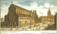
Here on the site of today's Promenade square stood the Salzstadel, where the salt was stored, to which Munich was responsible for a large part of its prosperity.
In the 17th and 18th centuries, nobles increasingly acquired land in the Kreuzviertel and erected representative palaces, especially in the area of Promenadeplatz, Prannerstraße and Kardinal-Faulhaber-Straße.
At the northern end of the rear Schwabinger Gasse (now Theatinerstraße) emerged the Theatinerkirche as a court church and the adjacent monastery of the Theatines.