Anadyrsky District
The district is located in a mountainous region, the peaks of which provide the catchment areas for the Anadyr River and its tributaries.
Following the foundation of the first Russian-speaking settlements by Semyon Dezhnyov, this territory became the key part of the region in terms of trade, exploration, and administration, which still continues today.
[13] The vastness of the district means that natural conditions within it vary considerably, from the mountainous tundra found in the north, to impenetrable woodland in the south, to wind-lashed coast to the east.
All of the major inhabited localities on the territory of the district (Anadyr, Ugolnye Kopi, and Shakhtyorsky) are found on the banks of this estuary.
[13] More southerly tributaries of the Anadyr River, such as the Mayn, have their sources in the spurs of the Koryak Mountains in the south of the district.
[13] A large part of the district is covered by the Anadyr Valley, consisting of two distinct sections: a plain extending from Anadyrsky Liman in the east approximately 500 kilometers (310 mi) to Markovo and a more elevated region within the Shchuchy Range.
The district is also home to Lake Elgygytgyn, found in the center of an impact crater created just under three and a half million years ago.
[14] The easternmost part of the district is covered by the Uelkalskaya tundra, and the area of the Anadyr Estuary contains a number of shingle spits and intertidal silt flats.
[13] Anadyrsky District contains four of the seven zakazniks (regional-level protected areas) in Chukotka, all of which are inherited from the times of the Soviet Union.
[15] Tundrovy zakaznik was established specifically to protect migrating and nesting birds including eiders, swans, and several species of goose.
[15] Ust-Tanyurensky zakaznik protects a transitional area between woodland and tundra also containing swans, geese, and other migratory birds.
These people either migrated to the Far East, or are the descendants of those who did, enticed by the higher pay, large pensions, and more generous allowances permitted to those prepared to endure the cold and the isolation, as well as those who were exiled here as a result of one of Stalin's purges after having been released from the Gulag.
The Koryaks, originally native across much of Siberia, were pushed into Kamchatka by the Evens,[17] but have now moved over the border into Chukotka as well and are now found in the southwest of the district.
Archaeological excavations performed near Lake Elgygytgyn revealed that Chukotka was populated by humans during the Early Neolithic period, where a Stone Age encampment has been uncovered.
The existence of a viable human population has been confirmed by further excavations near Lake Chirovoye, although the most impressive findings in the district have been found at Ust-Belaya,[21] as the area in the vicinity of the settlement was also populated during Neolithic times, and a toggled harpoon head found in a grave indicated that there was a viable walrus hunting economy present in the area around 3000 BCE.
At this time, an exploratory team including the Cossack Semyon Dezhnyov left the ostrog (fort) of Nizhnekolymsky, a settlement which still survives near Chersky in the present-day Sakha Republic, in search of furs and silver.
[23] Within only a few years men under the leadership of Dezhnyov killed the entire population of the Anadyrsky Liman[23] With the discovery of Kamchatka at the end of the 17th century, Anadyrsk's importance as an administrative and economic hub grew still further.
By the mid-18th century, a viable sea route to Kamchatka had been discovered and Anadyrsk consequently lost its importance as a regional hub, with Catherine the Great ordering its demolition in 1766.
Although there were still skirmishes with the local population, this attempt proved more successful and the Russians were able to make use again of the area around the former fort of Anadyrsk.
At the same time, a Russian-American Company employee named Pyotr Baranov established a small trading base on the site of present-day Anadyr.
[21] Exploitation of the various minerals to be found in the district did not begin until the early 20th century, when the Russian North-Eastern Siberian Society, an American conglomerate, began to extract gold and ship it back to the United States, though this enterprise ceased in 1912.
[21] Due to the distance between Anadyrsky District and Moscow, news of the October Revolution took nearly a month to arrive and even when it did, Bolshevik politics did not immediately seize control.
[21][24] It was not until 1923 that the revolutionary committee had removed all opposition, but the revolution had created serious economic problems, with the private companies that previously managed all of the fishing and general trade no longer in existence.
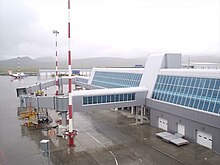
It is an important facility today, since it was built to accommodate large planes it is still a significant element in the district's underdeveloped transport infrastructure.
[13] Development of alluvial gold deposits has taken place in the foothills of the Belskiye Mountains, near Otrozhny, and near the source of the Mayn River.
[28] Although raising livestock is not a common activity in Chukotka, some people in Anadyrsky district keep small herds of Yakut horses.
[23] At the start of the 21st century, serious flooding in Anadyr itself resulted in significant damage to both public and private property, including serious power cuts.