Anders Bure
He worked in the royal chancery (the precursor to the Government offices) and in 1603 was commissioned to produce a map of the Nordic countries by the future King Charles IX of Sweden.
He was born on 14 August 1571 in the parsonage of Säbrå; his parents were Engelbertus Laurentii Bureus [sv] and his first wife Elisabet Andersdotter of the Bure kinship.
[6][7] The first tangible information about the life of Bure dates from 1602, when he was assigned to bring order to a collection of documents for the royal chancery (the precursor to the Government offices), later filed in the national archive.
[1][6] Johannes Bureus further mentions in his diary that Anders Bure discussed the use of astronomical instruments with him and made observations of stars from Stockholm Palace on at least one occasion.
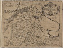
[b][1] The limited range of this map has been connected with the geopolitical ambitions of Charles IX, who entertained plans for a Swedish expedition towards the Arctic Ocean.
[9] Historian Erik Vennberg [sv] notes in the Dictionary of Swedish National Biography (Svenskt biografiskt lexikon) that "through its level of detail and correctness" the map constituted "extraordinary progress for its time, and was unprecedented in the Nordic countries".
Funding was supplied through royal patronage, including through a gift from King Gustavus Adolphus of more than 1,000 bibles, which Bure was to sell in order to get more money to the project.
[7][22] It was also less fantastical and lacked the depictions of imaginary beasts that decorate Carta marina, though in the northern parts of Scandinavia, Bure included images of reindeer and a bear.
"[24] It was quickly copied by cartographers abroad and became widely distributed through atlases, and formed the basis for almost all maps of Sweden published outside the country until the end of the 18th century.
[27] For example, it contains a comment on the lack of older written sources from Sweden, which the author attributes to the decline of the runic alphabet, implicating that if Swedish culture and history were only more well-known, they would be comparable to those of Ancient Greece or Rome.
[28][29] King Gustavus Adolphus however followed up on Bure's successes by creating a national body responsible for producing maps that could be of use both militarily and administratively, against a wider backdrop of "expansion abroad and consolidation at home", as put by the historian of geography Elizabeth Baigent.
[32][33] He set about training six surveyors, among them some who had collaborated with Bure in his earlier projects, and several of them had studied astronomy, mathematics or geometry at Uppsala University.
[34] The surveying task itself was comprehensive: all villages were to be mapped, with their fields, meadows, woodlands and bogs and other unusable land marked in separate colours.
[34] In fact, the King viewed the project as a wider modernisation programme, intended to propel Sweden forward through both investigation and action.