Angles, Alpes-de-Haute-Provence
Angles (French pronunciation: [ɑ̃ɡl]) is a commune in the Alpes-de-Haute-Provence department in the Provence-Alpes-Côte d'Azur region of southeastern France.
[3] National Highway N202 passes along the south-west edge of the commune in a tunnel with a country road branching north-east to the village then continuing south-east to Vergons.
The name refers to an element of the landscape shaped like a wedge: the village according to Ernest Nègre,[6] or the fields according to Fénié.
[9] The locality appears for the first time in charters from 1245[3][10] as it was a co-lordship of the bishops of Senez and the Abbey of Lérins.
[8] The inhabitants of Angles lead a struggle against the local lord over several generations and denied the rights of the half-lords to any inheritance.
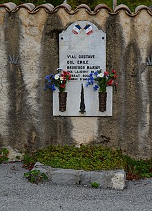
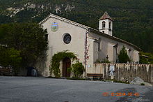
[3] In 1788 the priory disappeared with the secularization of Lérins Abbey[8] During the French Revolution the town had a patriotic society which was formed after the end of 1792.
List of Successive Mayors[16] The demographic history of Angles is marked by a period of "stagnation" where the population was relatively stable at a high level.
[21] At the end of 2015 the primary sector (agriculture, forestry, fisheries) had two establishments, and employed one person.
[21] The number of farms, according to the Agreste survey by the Ministry of Agriculture, remained stable in the 2000s at 3 which specialise in the breeding of sheep.
[36] The N202 national road can be used by trucks carrying dangerous goods[37] and pass within the limits of the commune.