Ano Doliana
[5] In recent years it has emerged as a relatively popular tourist destination, with a significant number of visitors during the autumn and winter season weekends, as well as for hikers, especially during spring.
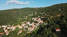
It extends at an altitude of 900 to 1.150 meters, built amphitheatrically on the northern slopes of mount Parnon, filled with fir, chestnut, platanus and cherry trees, surrounded by creeks and small waterfalls.
The village is spread in two neighborhoods and overlooks the plateau of Tripoli, with the visual horizon reaching the mountains of Mainalo, Artemisio, Helmos and Erymanthos.
The village was established as the primary residence of the settlers, who were mainly shepherds, leaving a pastoral life and herding livestock around open areas of land.
Doliana was used as a secondary settlement, in which the inhabitants migrated during the winter months to protect the animals from low temperatures and snow.
But with the modernization of life and the transformation of the main occupation of the inhabitants from livestock to cultivation, especially olive oil trees, the roles of the two settlements were reversed.
Over the years and because of the abandonment of its role as a basic settlement of the inhabitants, the village has managed to maintain its graphic character relatively intact, avoiding the extensive human interventions of the modern era.
At the entrance of Doliana and specifically at the point where the main battle unfolded, named "Tsakonas ravine", a honorable bust of Nikitaras has been erected.
Traditionally, the main repatriation of the inhabitants of Kato Doliana, as well as internal migrants and expatriates, takes place the week of the feast of Virgin Mary.
Due to its high altitude of 1.390 meters, it is also being used as a telecommunications hub for the wider region, with antennas transmitting signals for OTE, television, radio and mobile telephony.
[31][32] During the descent, the residents hand-carry the icon on a ritual hike that lasts several hours and passes through the old path that used to connect the two settlements before motorways were created.
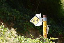
The cobbled streets and paths of the settlement regularly host the local downhill cycling championship,[38][39] on a route that has been named "Doli Stone Stairs" by the organizers.
[45][46] At an altitude of 1,100 meters and on the highest edge of the village, an artificial environmental settlement has been built by the local forestry authority with funding from the Ministry of Agricultural Development.
[48] A chalet, perched at an altitude of 1,090 meters, is the epicenter of Dasiko Horio, offering panoramic views of the Tripoli plateau and the surrounding region.