Antonio de Vea expedition
[1] While settled in Chacao, Chiloé, Cristóbal Talcapillán soon learned the basics of the local Veliche language[A] and begun to gain notoriety for his claims about the a presence of Europeans in the far south.
[1] Talcapillán told that an Indian called León who had been back and forth to England, and that there was a Spanish shipwreck in Lluctui, an island also controlled by the English.
[18] At the southern shores of San Rafael Lake the expedition was divided in two groups, one that was to stay behind waiting and one that was to advance further south crossing the isthmus of Ofqui by land.
This last group was made up by 40 Spaniards and 40 Indians led Antonio de Vea in person and included both Talcapillán and Bartolomé Gallardo.
[21] On December 25 and 26 the expedition ambushed and captured various indigenous Chono, including children and an old woman, in San Javier Island.
[21] The woman, who was judged by de Vea to be about 70 years old, reportedly told the Spanish about conflicts with an indigenous group known as Caucagues, who had iron obtained from anchors of European ships.
According to this interrogation, the woman explained that the Caucagues were warned of the Spanish expedition by an Indian who escaped from Calbuco in Chiloé and were thus hiding.
[25] Before returning north, the expedition left a bronze plaque in San Javier Island indicating the King of Spain's ownership of the area.
[26] Sixteen men of the party died on February 17 in the Evangelistas Islets, including the son of Pascual de Iriarte.
[29][30] The incident happened as a detachment approached the islets in a skiff to install a metal plaque indicating the King of Spain's ownership of the territory.
[30] Hit by strong winds, the boat drifted away and the remnant of the expedition in charge of Pascual de Iriarte could not find it.
[1][26][30] Antonio de Vea had concluded and successfully convinced Spanish authorities that rumours about English settlements in the fjords and channels of Patagonia were false.
[11][33] He noted that while there was an abundance of shellfish, sea lions and whales the establishment of a European settlement was not feasible given that adverse climate and poor soils made cultivation of crops impossible.
[34] The focus of Spanish attention to repel tentative English settlements shifted from the Pacific coast of Patagonia to the Straits of Magellan and Tierra del Fuego.
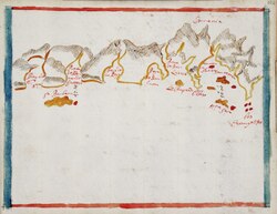
[3] As far as known today, no new Spanish maps were made of the west coast of Patagonia until José de Moraleda y Montero's explorations in the late 18th century.
[34] Following this expedition there was an apparent hiatus of several decades in both missionary activity and the search of possible foreign colonies in the Pacific coast of Patagonia.