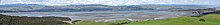
Aotea Harbour
[3] Most higher ground around the harbour is formed from Jurassic era graywacke stone, while the Aotea Harbour north head were formed from Quaternary marine deposits, wind blown north-east from the Tasman Sea.
[1] Waireinga/Bridal Veil Falls is located on Pakoka River, and Lake Disappear is on Pakihi Stream, both of which flow into Aotea Harbour.
Most of the land surrounding the Aotea Harbour is grassland with occasional pōhutukawa trees; however, archaeological charcoal evidence shows the presence of some tawa, rimu and kanuka trees, alongside Hebe and Coprosma shrubs.
[4] In the present day, some common plants found around the harbour are Cotula coronopifolia, Sarcocornia quinqueflora, Avicennia marina, Apodasmia similis, Selliera radicans, Plagianthus divaricatus, Paspalum vaginatum, Samolus repens, Juncus kraussii, Zostera novazelandica, Austrostipa stipoides, Isolepis cernua, Spartina anglica, Schoenoplectus pungens, Baumea juncea, Cordyline australis, Olearia solandri, Dacrycarpus dacrydioides, Leptospermum scoparium, Bolboschoenus fluviatilis, Coprosma propinqua, Cortaderia selloana, Cortaderia jubata and Typha orientalis.
[5] Birds recorded in the harbour include white faced heron, South Island oyster catcher, godwit, pied stilt, black backed gull, red billed gull, swan, Canada goose, spur-winged plover, New Zealand dotterel, Royal spoonbill, kingfisher, pied shag, fernbird, paradise duck,[5] Caspian tern, white-fronted tern and gannet.
[6] According to traditional history, the harbour is the final landing place for the Aotea waka.
[4] Many found on the Aotea Harbour north head, such as Koreromaiwaho Paa, were covered with Aeolian sand, blown due to the prevailing south-westerly wind.
Phillips Rd branches from Te Papatapu Rd, giving access to some areas north of the harbour.
[16] The bridges over the Maari and Makomako streams were built about 1918, though the road linking Kawhia and Te Mata was not usable until about 1926.