Arab, Alabama
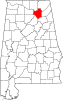
Arab (/ˈeɪ.ræb/ ⓘ) is a city mostly in Marshall County, with a portion in Cullman County,[7] in the northern part of the U.S. state of Alabama, located 10 miles (16 km) from Guntersville Lake and Guntersville Dam, and is included in the Huntsville-Decatur Combined Statistical Area.
[8] The current name of the town was an unintentional misspelling by the United States Postal Service in 1882 of the city's intended name, taken from Arad Thompson, the son of the town founder, who had applied for a post office that year.
"Arad" was one of three names sent to the Postal Service for consideration, the others being "Ink" and "Bird."
Arab has frequently been noted on lists of unusual place names.
[13] Arab is located at an elevation of 1,100 feet (340 m) on top of Brindlee Mountain, near the southwest end of the Appalachian Plateau.
The city lies on the Tennessee Valley Divide, with the north side draining either west to Cotaco Creek or east to Shoal Creek, both tributaries of the Tennessee River, while the south half of the city drains to the headwaters of the Mulberry Fork of the Black Warrior River, part of the Tombigbee River watershed.
Arab was incorporated as a town in 1892, but it did not first report a population on the census until the 1920 U.S.
In 1960, it was changed to the Arab Census Division as part of a general reorganization of counties.
[20] The census division only includes the Marshall County portion of the town of Arab.
The Cullman County portion is in the Baileyton-Joppa Census Division.
[21] Arab has a mayor-council form of city government consisting of five council members and a mayor.
Their fire department has one station, sitting on top of Marshall County 911 center.
Residents are in the Arab City School District, regardless of county.