Ararat, Victoria
Ararat (Djabwurrung: Tallarambooroo)[2] is a town in the Central Highlands region in Victoria, Australia, about 198 kilometres (120 mi) west of Melbourne, on the Western Highway on the eastern slopes of the Ararat Hills and Cemetery Creek valley between Victoria's Western District and the Wimmera.
[3] It is the largest settlement in the Rural City of Ararat local government area and is the administrative centre.
[6] Prior to the European settlement of Australia, Ararat was inhabited by the Djab wurrung group of Aboriginal Australian people.
In 1841, Horatio Wills, on his way to selecting country further south, wrote in his diary, "like the Ark we rested" and named a nearby hill Mt Ararat.
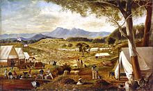
By building reservoirs and carefully contouring the aqueducts or channels these companies could wash out the gold bearing soil on the higher ground which the alluvial miners had not been able to reach.
[12] Similar difficulties were faced by all deep lead speculators including well after the turn of the century.
[12] A final effort at deep lead mining in 1932 failed before achieving production, ending what might be called the professional gold era in Ararat.
'Ararat’s main goldfields have produced a great deal of gold to detector operators and will continue to do so for many years.
'[14] The rapid growth generated by gold brought about a municipality, which was incorporated as a borough on 24 September 1858.
The Aradale Mental Hospital opened in 1865 with the former the Ararat County Gaol converted in 1887 to J Ward, a psychiatric facility for the criminally insane.
The Hospital remained open as a treatment facility until 1997 and has since become the site for paranormal and haunted house tours.
The formally recognised traditional owners for the area in which Ararat sits, north-west of Campbell Street and the Pyrenees Highway and north-east of the Western Highway and Lambert Street are the Wotjobaluk, Jardwadjali (also known as Jaadwa), Wergaia and Jupagalk nations.
[16] The formally recognised traditional owners for the area in which Ararat sits, south-east of Campbell Street and the Pyrenees Highway are the Djab Wurrung people.
[15] The Djab Wurrung people are represented by Martang Pty Ltd.[17] In the area of Ararat that is south-west of the Western Highway and Lambert Street, traditional owners have not yet been formally recognised.
However, the Eastern Maar people are negotiating a recognition and settlement agreement with the Victorian Government.
It is also home to AF Gason Pty Ltd one of Australia's largest manufacturers of farm machinery and wood heating.
Hopkins Correctional Centre, formerly known as H.M. Prison Ararat, is located on the town's eastern outskirts.
Servicing visitors to the Grampians National Park and the local wine industry, tourism is a relatively small but significant industry in Ararat, employing 150 people and generating around $8 million to the economy, however its impact on the surrounding region is significant with tourists spending $270 million annually.
[19] Key tourist attractions include the Ararat Regional Art Gallery, Mount Langi Ghiran winery, tours through Aradale (Australia's largest abandoned 1800s lunatic asylum) and the Gum San Chinese Heritage Centre.
Cemetery Creek, the valley's main catchment runs through the north of the town while Green Hill lake is on the city's eastern fringe.
Ararat has a temperate Mediterranean climate (Köppen Csb), with warm summers that are frequently interrupted by cold fronts; and cool, usually rainy, winters.
[37] Ararat Harness Racing Club conducts regular meetings at its racetrack in the town.
[40] Motocross has become a popular sport in the area, and the Ararat Motorcycle Club regularly holds events up to state level.
Association football is played at junior level, with the Ararat and Grampians YMCA school competition from years 8–12.
Popular tourist destinations include the Gum San Chinese Heritage Centre, Aradale Lunatic Asylum Tours,[44] Langi Morgala Museum, The Astor Cinema, and J Ward.
All sit on the Police Camp block, which was bounded by Barkly, Ligar, High and Ingor Streets.
[45] [46] It was the first Victorian Post Office to be designed in the Italianate style with, for example, an arched arcade or loggia (since filled in).
The town had been linked by telegraph since1858 when the line was extended from Ballarat via a Post Office that was variously called Raglan, Firey Creek, or Beaufort.
These Courts sat in a bluestone building on the corner of High and Vincent Streets that is now the site of the municipal offices.
[56] Olivers Gully and Copes Hill reservoirs provide additional water storage.