Ararat Province
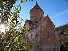
It is also home to the Khor Virap monastery, significant as the place of Gregory the Illuminator's 13-year imprisonment and the closest point to Mount Ararat within Armenian borders.
According to Movses Khorenatsi and the Ashkharatsuyts medieval Armenian geographical book of Anania Shirakatsi, Ayrarat was one of the 15 provinces of Armenia Major.
The highest point of Ararat province is the Spitakasar peak of Gegham mountains with a height of 3560 meters.
The cliffy terrain of Khosrov Forest located at the northeast of the province, used to be the stronghold of the Endangered Caucasian leopards in Armenia.
[7] The region of modern-day Ararat Province is among the earliest locations that was settled by the people of the Armenian Highland.
The other cantons of Urtsadzor and Arats were first mentioned in the 5th century AD by Yeghishe the historian in his "History of Vardan and the Armenian War" historical work.
After the fall of the Armenian Kingdom in 428, the region became part of the Sasanian Empire of Persia until the Arab conquest of Armenia in the mid-7th century.
According to the 8th-century historian Ghevond, the Armenian princes of Urtsadzor canton participated in the failed revolution of 775 in Erciş against the Abbasid rulers of Arminiya.
However, between the 11th and 15th centuries, the region suffered from the Seljuk, Mongol, Ag Qoyunlu and Kara Koyunlu invasions, respectively.
At the beginning of the 16th century, the territory of modern-day Ararat became part of the Erivan Beglarbegi within the Safavid Persia.
It remained under the Persian rule until 1827–1828, when Eastern Armenia was ceded by the Russian Empire as a result of the Russo-Persian War of 1826–28 and the signing of the Treaty of Turkmenchay.
With the fall of the Russian Empire and as a result of the decisive Armenian victories over the Turks in the battles of Sardarabad, Abaran, and Gharakilisa, the region became part of the independent Armenia in May 1918, however, its western reaches remained occupied by the Ottoman Empire (by virtue of the Treaty of Batum) until the latter's withdrawal in late 1918.
In July 1919, lasting until mid-1920, the Azerbaijanis-inhabited regions of Ararat, Vedibasar and Zangibasar, revolted against the Armenian government as part of the Muslim uprisings in Kars and Sharur–Nakhichevan.
The regulating body of the church is the Araratian Pontifical Diocese, headed by Archbishop Navasard Kchoyan (seat in Yerevan).
The M-2 Motorway that connects the capital Yerevan with southern Armenia and the Iranian border, passes through the Ararat Province.
The towns of Artashat and Ararat used to have a railway station that connected Yerevan with the Nakhchivan Autonomous Republic during the Soviet years.
Being located at the fertile Ararat plain, the province contributes with 15% in the annual total agricultural product of Armenia.
Other products include pear, apple, melon, watermelon, eggplant, grains and dry seed.
At the end of 2001, another football club with the name of FC Araks was founded in Ararat, but lasted only 4 years before being dissolved.