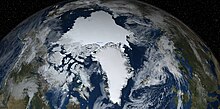
Arctic ice pack
Besides the regular seasonal cycle there has been an underlying trend of declining sea ice in the Arctic in recent decades as well.
This production of dense water is essential in maintaining the thermohaline circulation, and the accurate representation of these processes is important in climate modelling.
The Odden (the word is Norwegian for the headland) grows eastward from the main East Greenland ice edge in the vicinity of 72–74°N during the winter because of the presence of very cold polar surface water in the Jan Mayen Current, which diverts some water eastward from the East Greenland Current at that latitude.
Records of Arctic Sea ice from the United Kingdom's Hadley Centre for Climate Prediction and Research go back to the turn of the 20th century, although the quality of the data before 1950 is debatable.
From the late 1970s, the Scanning Multichannel Microwave Radiometer (SMMR) on Seasat (1978) and Nimbus 7 (1978–87) satellites provided information that was independent of solar illumination or meteorological conditions.
[9] In 2007, the minimum extent fell by more than a million square kilometers, the biggest decline since accurate satellite data has been available, to 4,140,000 km2 (1,600,000 sq mi).
New research shows the Arctic Sea ice to be melting faster than predicted by any of the 18 computer models used by the Intergovernmental Panel on Climate Change in preparing its 2007 assessments.


(Record position 85°40.7818 ′ N, 135°38.8735 ′ E)