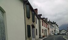
Arette
Arette (French pronunciation: [aʁɛt]; Occitan: Areta) is a commune in the Pyrénées-Atlantiques department in the Nouvelle-Aquitaine region of southwestern France.
Access to the commune is by French rail SNCF to Pau, and a short bus ride to Arrete.
Less scenic is the automobile route: D918 road from Lanne-en-Barétous in the north-west coming south-east to the village then continuing east to Issor.
The D132 goes south from the village down the length of the commune following a tortuous mountain route before exiting the southern border of the commune over the Col de la Pierre St Martin (1,760m), which is also the border with Spain, and becoming the Spanish NA-137 which continues to Isaba.
From Pic d'Anie the mountain range extends downwards for approximately 20 km, forming both sides of the Aspe Valley to the north-west.
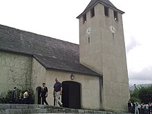
The ruined clock tower of the church indicated the exact time of the earthquake: 11:10 p.m. Seismic waves were felt from Pau to Tarbes and Bayonne.
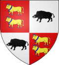
[16] Quarterly, 1 and 4 Gules with two cows of Or hooved, collared, belled, and horned in Azure one above the other; 2 and 3 Argent with a boar of Sable.
Percentage Distribution of Age Groups in Arette and Pyrénées-Atlantiques Department in 2017 Source: INSEE[20][21] The economy of the commune is primarily oriented toward agriculture and livestock (cattle and sheep) and logging.