Argen
The origin of the Untere Argen is the confluence of Börlasbach and Stixnerbach at the western entrance to Missen at about 850 metres (2,790 ft) above sea level in the Allgäu region of Bavaria.
From the confluence, it first flows north to Isny im Allgäu, then northwest to Waltershofen, then southwest to Primisweiler.
It initially flows through the Eistobel gorge, then underneath the Argentobelbrücke, and past Grünenbach towards Wangen im Allgäu.
Geomorphologically, the Argen has cut a deep and wide valley into the landscape, leading to such place names as Gitzensteig.
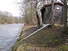
In recent years the massive concrete walls alongside the river have been replaced with large boulders in most of the shallower zones.
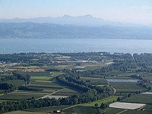
Near the estuary at Kressbronn, gravel is mined in larger quantities, creating new lakes along the river.
An area of approximately 296 hectares (730 acres) flanking the Argen was declared a nature reserve by the regional council of Tübingen on 16 December 1997.
The reserve covers the area between the confluence of the Obere and Untere Argen and the mouth into Lake Constance.