Arlington, Oregon
[citation needed] Originally named Alkali,[7] Arlington came into existence as a place for shipping cattle down the Columbia River.
[citation needed] It was incorporated as Arlington by the Oregon Legislative Assembly on November 20, 1885.
[7] The original townsite was demolished beginning in 1965 due to the scheduled inundation of Arlington by the rising waters of the Columbia River to form Lake Umatilla behind the John Day Dam.
[8] In 2008, it was discovered that Mayor Carmen Kontur-Gronquist had posted photos of herself in lingerie online,[9] which, along with several other issues, led to her recall from office.
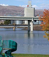
The area around Arlington is largely agricultural farm land with wheat, barley and beef cattle being the principal products.
[citation needed] Arlington is home to a sizable Waste Management landfill, notably receiving all of Seattle, Washington's trash and some from Portland, Oregon.
It officially opened in September 2012 and "reached full commercial operations in November 2012.
[42] In fall 2017, construction was started on the Montague Wind Power Project, a project owned and operated by Avangrid Renewables to provide power to Apple Inc.'s Prineville Data Center through Oregon's Direct Access Program.
On April 20, 2020, Avangrid requested to change the boundary and site layout of its Montague Wind Power Facility.
I-84 travels west towards Portland and east towards Boise, Idaho; OR 19 connects Arlington to Condon and U.S. Route 26 near Dayville.
In 2011, the U.S. Air Force proposed Arlington as the site of a future United States Department of Defense unmanned aerial vehicle base.