Arthur's Pass
At an elevation of 740 metres (2,430 ft) above sea level, the settlement is surrounded by beech forest.
The town is located 153 kilometres (95 mi) from Christchurch, a two-hour drive on State Highway 73.
The Chief Surveyor of Canterbury Province, Thomas Cass, had tasked Arthur Dobson to find out if there was an available pass out of the Waimakariri watershed into valleys running to the West Coast.
In 1864 Arthur's brother Edward Henry Dobson joined him and accompanied him over the watershed into the valley of the Ōtira River.
When Arthur returned to Christchurch, he sketched the country he had traversed and included it in a report to Cass.
At the same time George Dobson, (another brother), was sent to examine every available pass between the watershed of the Taramakau, Waimakariri, and the Hurunui.
[5] The railway from Christchurch reached Arthur's Pass township in 1914, the Westland section having advanced to Otira.
Construction of the tunnel was very slow; it finally finished in 1923, and its opening marked by the British and Intercolonial Exhibition.
[9][failed verification] Arthur's Pass is described by Statistics New Zealand as a rural settlement, and covers 0.27 km2 (0.10 sq mi).
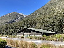
[14] New Zealand's first national park visitor centre was built in Arthur's Pass in 1959, with the help of the Christchurch Wanderers Tramping Club.
It was designed by Christchurch architect Paul Pascoe and used local stone to reflect the geology of the national park.
There are also several good walks from here, including the Devil's Punchbowl Falls,[19] Bealey Valley[20] and Avalanche Peak.