Asana River
The river's runoff source is seasonal precipitation including snow melt from the western cordillera of the Andes.
In the flat valley where the Asana archaeological site is located, the geological and geomorphological features are causative factors for its existence.
[6] The lower sierra region (2,500–3,400 metres (8,200–11,200 ft)) of the Asana river valley has four plant communities; evergreen shrubs and sparsely distributed molle trees (schinus molle); perennial shrubs of Franseria meyeniana; grasses and herbs such as Chenopodium petiolare and grain quinoa (Chenopodium quinoa).
Some of the species are Fabiana weberbauerii, Balbisia-Verbena Diplostephium, Cherodesma and tola (Parastrephia lepidophyllum) pampa, stipa ichu, quenua (Polylepis besseri), and in the High Sierra – Bofedales (Distchia moor).
Recorded from the pre-historic period, are guanaco (Lama guanicoe) in an elevation range of 4,200 metres (13,800 ft) feeding on grasses, forbs and shrubs, and subsisting in arid conditions.
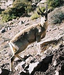
Taruca (Hippocamelus antisensis) is found in elevation up to 4,600 metres (15,100 ft) in scattered forest environment of groves (quenua); they still exist in the valley.
Quellaveco proposed a river diversion project on the Asana River in 2000 which involved the building of a 7.2 kilometres (4.5 mi) canal which would use 700 liters (150 imp gal; 180 U.S. gal) per second of water for open pit mining to extract about 64,000 tons of copper, and other minerals, over a forty-year period.
Other issues noted were resettlement of local population as well as the pollution of aquifers and land area caused by discharge of tailing effluents.