Athabasca oil sands
[4][6][7][8][9][10][11] The Athabasca oil sands, along with the nearby Peace River and Cold Lake deposits oil sand deposits lie under 141,000 square kilometres (54,000 sq mi) of boreal forest and muskeg (peat bogs) according to Government of Alberta's Ministry of Energy,[12] Alberta Energy Regulator (AER) and the Canadian Association of Petroleum Producers (CAPP).
In 1888, Robert Bell, the director of the Geological Survey of Canada, reported to a Senate Committee that "The evidence ... points to the existence in the Athabasca and Mackenzie valleys of the most extensive petroleum field in America, if not the world.
Photos of the Athabasca oil sands were also featured in Canadian writer and adventurer, Agnes Deans Cameron's, best-selling book The New North which recounted her 10,000 mi (16,000 km) roundtrip to the Arctic Ocean.
[17] Her photographs were reproduced in 2011–2012 in an exhibit at the Canadian Museum of Civilization in Ottawa,[18] and included photos of Count Alfred Von Hammerstein's oil drill works along the Athabasca River.
[40] Other projects, using existing rights of way, are being built, like Kinder Morgan's Trans Mountain Expansion, nationalized in 2018, or Enbridge's Line 9, reversed to feed refineries in Quebec.
[44] As of December 2008, the Canadian Association of Petroleum Producers revised its 2008–2020 crude oil forecasts to account for project cancellations and cutbacks as a result of the price declines in the second half of 2008.
In early December 2007, London-based BP and Calgary-based Husky Energy announced a 50–50 joint venture to produce and refine bitumen from the Athabasca oil sands.
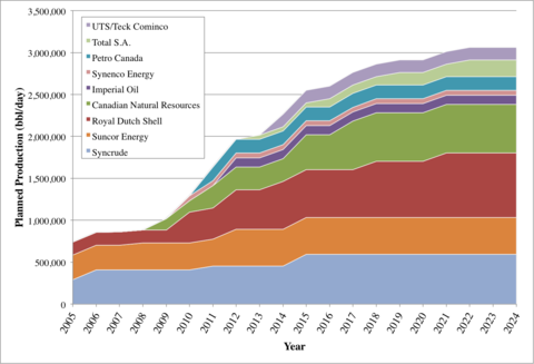
Other major oil sands producers planning to increase their production include Royal Dutch Shell (to 770,000 bbl/d (122,000 m3/d)); Syncrude Canada (to 550,000 bbl/d (87,000 m3/d)); Suncor Energy (to 500,000 bbl/d (79,000 m3/d)) and Canadian Natural Resources (to 500,000 bbl/d (79,000 m3/d)).
This will include integrated and coordinated monitoring of land, air, water and biodiversity," said a press release from Diana McQueen's office, the Minister of Energy and Sustainable Development.
[72] The provincial government moved to develop the agency after widespread public criticism by environmentalists, aboriginal groups and scientists, who claimed the oil sands would have a devastating, long-term effect on the environment if left unchecked.
Until 2009, the surface mineable area (SMA) was defined by the ERCB, an agency of the Alberta government, to cover 37 contiguous townships (about 3,400 km2 or 1,300 sq mi) north of Fort McMurray.
[83] After excavation, hot water and caustic soda (sodium hydroxide) is added to the sand, and the resulting slurry is piped to the extraction plant where it is agitated and the oil skimmed from the top.
Approved oil sands mining operations are currently licensed to divert 359 million m3 from the Athabasca River, or more than twice the volume of water required to meet the annual municipal needs of the City of Calgary.
The Athabasca River is the largest freshwater delta in the world but with Suncor and Syncrude leaking tail ponds the amount of polluted water will exceed 1 billion cubic meters by 2020.
Oil sands development contributes arsenic, cadmium, chromium, lead, mercury, nickel and other metal elements toxic at low concentrations to the tributaries and rivers of the Athabasca.
[123] Tailings ponds are engineered dam and dyke systems that contain solvents used in the separation process as well as residual bitumen, salts and soluble organic compounds, fine silts and water.
[133] The Pembina Institute suggested that the huge investments by many companies in Canadian oil sands leading to increased production results in excess bitumen with no place to store it.
It added that by 2022 a month's output of waste-water could result in a 11-foot-deep (3 m) toxic reservoir the size of New York City's Central Park [840.01 acres; 339.94 hectares; 3.3994 square kilometres].
[134] The oil sands industry may build a series of up to thirty lakes by pumping water into old mine pits when they have finished excavation leaving toxic effluent at their bottoms and letting biological processes restore it to health.
The subsidiary of China's CNOOC Ltd. automated safety systems had not detected the pipeline fault that caused the spill to cover an area of about 16,000 square metres prior to manual inspection.
The area is only sparsely populated, and in the late 1950s, it was primarily a wilderness outpost of a few hundred people whose main economic activities included fur trapping and salt mining.
However, while the Orinoco deposits are less viscous and more easily produced using conventional techniques (the Venezuelan government prefers to call them "extra-heavy oil"), they are too deep to access by surface mining.
[150] An agreement has been signed between PetroChina and Enbridge to build a 400,000 barrels per day (64,000 m3/d) pipeline from Edmonton, Alberta, to the west coast port of Kitimat, British Columbia.
First Nations groups also claim that the development of the proposed pipeline is in violation of commitments that the Government of Canada has made through various Treaties and the UN Declaration of the Rights of Indigenous Peoples.
[155] Opposition remaining within the First Nation focuses on environmental stewardship, land rights, and health issues, like elevated cancer rates in Fort Chipewyan[156] and deformed fish being found by commercial fishermen in Lake Athabasca.
While many companies argue that there are not enough chemicals and toxic material in the water due to the development of the oil sands, this report indicates that there is coincidentally a significantly higher rate of cancer within this community.
[158] From 2010 to 2014, the Tar Sands Healing Walk, founded by Indigenous women, was held annually as a demonstration against oil extraction and the damage it caused to local communities and the environment.
First Nations in Alberta have called particular attention to adverse health impacts related to oil sands emissions, asserting that the water quality testing for specific chemicals (heavy metals) has been insufficient.
In fact, over the past two decades, First Nations participation in the energy sector has increased dramatically, from employment and business opportunities to project approval processes and environmental evaluation.
[161] Enhanced participation in the energy sector has empowered many Indigenous groups to push for wider involvement by negotiating ownership stakes in proposed pipelines and bitumen storage projects.