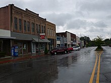
Attalla, Alabama
The wealthier ones developed cotton plantations based on the labor of enslaved African Americans.
Cherokee people had also lived in this area, after being encroached on in Tennessee and western North Carolina.
Attalla was not founded until 1870; it was established on land donated by W. C. Hammond, a plantation owner.
The town was officially named "Attalla" in 1893, derived from the Cherokee language word otali meaning "mountain".
When the railroads went into bankruptcy, Attalla's prosperity declined in the late 19th century financial troubles.
[citation needed] Attalla is the site of the first hydroelectric dam constructed to provide electricity for a city; it was built in 1887.
[7] William Lewis Moore, a white U.S. postman and civil rights activist, was murdered here on April 23, 1963.
U.S. Route 11 passes through the center of town as Third Street and runs generally parallel to I-59, leading northeast 36 miles (58 km) to Fort Payne and southwest 58 miles (93 km) to Birmingham.
Routes 278 and 431 also pass through the center of Attalla, leading east 5 miles (8 km) to downtown Gadsden.
According to the U.S. Census Bureau, the city has a total area of 7.0 square miles (18.1 km2), all of it land.
[4] Big Wills Creek, a tributary of the Coosa River, flows southeasterly through the city.
The southern end of Lookout Mountain rises to the east overlooking the city.
As of the 2020 United States census, there were 5,827 people, 2,151 households, and 1,364 families residing in the city.
In 1960, the precinct was changed to "census division" as part of a general reorganization of counties.