Au Sable River (Michigan)
Rising in the Northern Lower Peninsula, the river flows in a generally southeasterly direction to its mouth at Lake Huron at the communities of Au Sable and Oscoda.
The Au Sable has a drainage basin of 1,932 square miles (5,000 km2)[6] and an average flow of 1,100 ft3/s (31 m3/s) at its mouth.
The North Branch Au Sable River joins within approximately 5 miles (8.0 km) in eastern Crawford County at 44°40′14″N 84°22′51″W / 44.67056°N 84.38083°W / 44.67056; -84.38083 (North Branch Au Sable River (mouth)) near the boundary with Oscoda County.
The Lumberman's Monument, in honor of the lumberjacks that first populated the area, is located on the river about 15 miles (24 km) west of Oscoda.
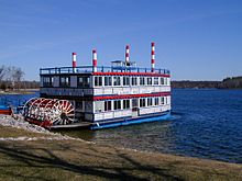
There are six hydro-electric power plants in the Au Sable River basin, with a total installed capacity of 41 MW and an average annual energy output of 500 GJ.
The Au Sable has about 350 miles (560 km) of tributary streams including the Pine River.
Ordered from upriver to downriver, all belonging to the power company Consumers Energy: [13] The river has five historical markers on it: