Aubignosc
Aubignosc (French pronunciation: [obiɡnɔsk]; Occitan: Aubinhòsc) is a commune in the Alpes-de-Haute-Provence department in the Provence-Alpes-Côte d'Azur region of south-eastern France.
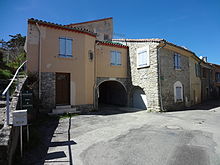
[4] The village is located at 460 metres above sea level[5] on the eastern slope of the valley of the Durance.
South of the village is hilly terrain with carved valleys and gullies over 600 metres deep.
[7] The commune lies between Forcalquier (south-west), Digne-les-Bains to the east and Gap farther north.
The D951 comes from Peipin in the north and passes south through the west of the commune and continues to Mallefougasse-Augès in the south-west.
There is a short hiking trail (equestrian route) passing through the commune from north to south.
The entire eastern border of the commune is formed by the Durance as it flows south to eventually join the Rhône at Avignon.
Several intermittent streams trickle down the slopes and the Faillée gorge (east of the Lure mountain), and through the Prieuré forest.
The commune lies on the eastern edge of Lure mountain with Provençal limestone formations of the Upper Jurassic and Lower Cretaceous periods (sedimentary rocks from a former Alpine Ocean), between several major geological formations of the Alps:[10] None of the 200 communes of the department are in a no seismic risk zone.
Farther south, along the Durance fault, the cantons of Peyruis, Les Mees, Manosque-Nord, Manosque-Sud-Est, Manosque-Sud-Ouest, and Valensole are in Zone 2 (medium risk).
[21] The toponymy of the commune is influenced by the mountainous character of the region, the Mediterranean climate, and the Occitan culture.
[22] Erosion, aggravated by deforestation, washes pebbles from the mountains that accumulate at the bottom of slopes: this kind of area is called Gravas (near Forest);[23] the Roubines refer to black marl or clay - i.e. robines in French.
[23] Human occupation and land use have resulted in several specific names: there are several places called Grand-Champ; Condamine is manorial land, indivisible and exempt from taxation;[23] Forest is a hamlet - not in a forest but an isolated village.
During the construction of the A51 autoroute a prehistoric site was excavated at Ponchonnières which was occupied by the Chasséen, then the Neolithic, and finally the Chalcolithic peoples around 3000 B.C.
[25] Anthracological studies have shown that the wood used for fires was oak (green or pubescent) which shows that the forest was still quite widely present at this time.
[30] The quality of the construction of the village at Présidentes is fairly average: the walls are made of pebbles and the mortar is simple lime.
[21] While the south-east of Gaul was Burgundian land, the king of the Ostrogoths, Theodoric the Great, conquered the region between the Durance, the Rhône, and Isère in 510.
In order to reconcile with the Burgundian king Godomar III, the Ostrogothic regent Amalasontha gave him the territory.
[32] In the Middle Ages the Aubignosc community was part of the viguerie of Sisteron[33] and the Abbey of Cruis owned a priory.
[34] The Aubignosc community had the privilege of not paying queste (similar to Taille) to the Counts of Provence (and their successors, the kings of France) until the French Revolution.
[35] Following a dispute between the priest and his parishioners, a large part of the community embraced Protestant worship en masse.
[36] After the French coup of 1851 of 2 December by Louis-Napoleon Bonaparte, the areas around Sisteron, Forcalquier, and Manosque developed a resistance movement to defend the Republic: 15,000 armed men were mobilized.
After the failure of the insurrection severe repression continued for those who stood to defend the Republic: 8 inhabitants of Aubignosc were brought before the Joint Commission, the most common punishment being deportation to Algeria.
[37] As with many communes in the department Aubignosc had schools well before the Jules Ferry laws: in 1863 it had two - installed in the main village and also in Forest - which provided primary education for boys.
At that time the nearby town of Sisteron was bombed by the Allies as part of the Provence landings.
According to its size, the commune has a municipal council of 15 members (Article L2121-2 of the General Code of local authorities[44]).