The approximately 53 volcanoes[2] in the field have produced a diverse array of maars (explosion craters), tuff rings, scoria cones, and lava flows.
[6] The field is fuelled entirely by basaltic magma, unlike the explosive subduction-driven volcanism in the central North Island, such as at Mount Ruapehu and Lake Taupō.
[21] Tāmaki Māori myths describe the creation of the volcanic field as a creation of Mataaho (the guardian of the earth's secrets) and his brother Rūaumoko (the god of earthquakes and volcanoes), made as punishment against a tribe of patupaiarehe, supernatural beings living in the Waitākere Ranges, who used deadly magic from the earth to defeat a war party of patupaiarehe from the Hunua Ranges.
[22][23] In some traditions, the fire goddess Mahuika creates the volcanic field as a way to warm Mataaho, after his wife leaves and takes his clothing.
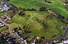
Many of the maunga (mountains) were occupied by substantial Māori pā (fortifications) before Pākehā settlement, and many terraces and other archeological remnants are still visible.
[27] Many of the cones have been levelled or strongly altered, in small part due to the historical Māori use, but mostly through relatively recent quarrying of construction materials (especially scoria).
[27] In the 1880s, Takarunga / Mount Victoria and Maungauika / North Head were developed as military installations due to fears of a Russian invasion.
[27] The cones are also protected by a 1915 law, the Reserves and Other Lands Disposal and Public Bodies Empowering Act 1915, which was passed due to early concern that the distinctive landscape was being eroded, especially by quarrying.
The legislation specified that the land be held in trust "for the common benefit of Ngā Mana Whenua o Tāmaki Makaurau and the other people of Auckland".
Most eruptive events in the field have been small volume, very constrained in time, typically involving less than 0.005 km3 (0.0012 cu mi) of magma making its way to the surface.
[20] Modelling has suggested that the next eruption in the volcanic field is likely to be associated with water and in the area extending from the central city to its north and northeast suburbs surrounding and including the Waitemata Harbour.
Auckland also has a seismic monitoring network comprising six seismometers—including one 250 metres (820 ft) deep at Riverhead—and three repeaters within the region that will detect the small tremors likely to precede any volcanic activity.
The quarried out cone of Rarotonga / Mt Smart is now Mt Smart Stadium, 2018
Site of Styaks Swamp buried beneath buildings and road, 2009
Site of quarried away Takaroro / Mt Cambria, 2018
Takarunga / Mount Victoria, 2018
Taurere / Taylors Hill, 1994
Te Apunga-o-Tainui / McLennan Hills, Painting by G.H. Cooper, 1861, Auckland Art Gallery
Te Hopua, 2018
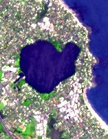
Panmure Basin, 2009
Te Kopua Kai-a-Hiku / Panmure Basin with
Maungarei
/ Mount Wellington behind
Te Kopua-o-Matokamokamo / Tank Farm, 2009
Onepoto explosion crater and tuff ring, 2009
Te Kōpuke / Tītīkōpuke / Mount St John, 2009
Crater of Te Kōpuke / Tītīkōpuke / Mount St John
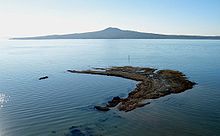
Te Motu-a-Hiaroa / Puketutu Island Volcano, 2018
Te Pane-o-Mataaho / Māngere Mountain, 2009
Te Pane-o-Mataaho / Māngere Mountain from the east
Site of Te Pou Hawaiki is now a three-storey concrete carpark building, 2018
The buildings in the middle of the photo are on the site of quarried away Te Puke ō Tara / Otara Hill volcano, 2009
The entire crater and tuff ring of Te Tātua-a-Riukiuta / Three Kings
Quarrying has removed two of the Tātua-a-Riukiuta / Three Kings
The site of Te Tauoma / Purchas Hill, 2018
Waitomokia explosion crater and tuff ring, 2018
Whakamuhu / St Heliers Volcano, 2009
The Glover Park sports ground at lower right of this photo is situated within the Whakamuhu tuff ring. Over the water in the distance on the right is the
scoria
cone of
Maungauika / North Head
and in the left middle is the tuff crater filled in by the sea of
Ōrākei Basin
. Beyond Ōrākei Basin in the middle distance are several vegetation covered scoria cones.
Site of quarried away Matukutururu / Wiri Mt, 2018