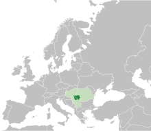
Banat
During the Middle Ages, the term "banate" designated a frontier province led by a military governor who was called a ban.
A first theory claims that it comes from the root of a verb found in several Germanic peoples, namely ban.
[3] At the time of the medieval Hungarian kingdom, the territory of modern Banat appeared in written sources as Temesköz (first mentioned in 1374).
Banat is defined as the part of the Pannonian Basin bordered by the Danube to the south, the Tisza to the west, the Mureș to the north and the Southern Carpathians to the east.
[11] The Romanian Banat is mountainous in the south and southeast, while in the north, west and southwest it is flat and in some places marshy.
The largest stretch of sand in Europe, today stabilized and covered with vegetation, Deliblatska Peščara, also lies in Serbian Banat.
[12] The climate of Banat is predominantly temperate (Cfb, according to Köppen classification), with a northeastward increase of continental and orographic effects (Dfb).
Frequent cyclones from the Mediterranean cause positive precipitation anomalies especially in the western parts and, due to the maritime influence, winters are mild and short, but when northeastern conditions prevail, harsh frosts may occur.
[14] The Danube forms between Baziaș and Porțile de Fier, over a distance of 140 km, the so-called Iron Gates.
[15] The Bega/Begej springs from the Poiana Ruscă Mountains, crosses the area of Făget and Lugoj, passes through Timișoara, then descends through a channel, flowing into the Tisza, at Titel.
Roman rule had a significant impact: castra and guard stations were established and roads and public buildings built.
The area fell into the hands of foederati such as the Sarmatians (Iazyges, Roxolani, Limigantes) and later the Goths, who also took control of other parts of Dacia.
An inscription on one of the vessels from the Treasure of Sânnicolau Mare (which origin is disputed) recorded names of two local rulers, Butaul and Buyla, who bore Slavic ruling titles of župan.
According to Gesta Hungarorum chronicle, a local ruler known as Glad ruled over Banat and his army was formed by Vlachs, Bulgarians, and Cumans.
[18] In the eastern part of the Carpathian basin the Byzantine rite became more influential after Ajtony's (Latin: Ahtum) conversion to Christianity.
He was a semi-independent ruler of Banat and a formally baptized Christian who constructed a Byzantine monastery at Morisena, but still kept 7 wives and worshiped Pagan gods at his Court.
In the 14th century, the region became of priority concern to the Kingdom, as the southern border of Banat was the most important defensive line against Ottoman expansion from the southeast.
In the spring of 1594, shortly after the beginning of the Austro-Turkish War (1593-1606), local Serbian Christians,[20][21] in the Eyalet of Temeşvar, started an uprising against Turkish rule.
[22] In the middle of the 17th century, the territory of Banate of Lugoj and Caransebeș finally fell under Turkish rule and was incorporated into Eyalet of Temeşvar.
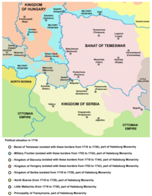
Under the Treaty of Karlowitz (1699), northern parts of the Eyalet of Temeşvar were incorporated into the Habsburg monarchy, but the territory of Banat remained under Turkish rule.
The Banat of Temeswar province was abolished in 1778, when civilian part of the region was incorporated into the Kingdom of Hungary and divided into counties.
During the Ottoman rule, parts of Banat had a low population density due to years of warfare, and some local residents also died during Habsburg-Ottoman wars and Prince Eugene of Savoy's conquest.
He recruited German artisans and especially farmers from Bavaria and other southern areas as colonists, allowing them privileges such as keeping their language and religion in their settlements.
[24] Maria Theresa also took a direct interest in Banat; she colonized the region with large numbers of German farmers, who were admired for their agricultural skills.
[25] In 1779, the Banat region was incorporated into the Habsburg Kingdom of Hungary, and the three counties of Torontal, Temes and Karasch were created.
In the wake of the Declaration of Union of Transylvania with Romania on December 1, 1918, and the Declaration of Unification of Banat, Bačka and Baranja with Serbia on November 25, 1918, most of Banat was (on July 26, 1919) divided between Romania (Krassó-Szörény completely, two-thirds of Temes, and a small part of Torontál) and the Kingdom of Serbs, Croats and Slovenes (most of Torontál, and one-third of Temes).
At the dissolution of Austria-Hungary, the delegates of the Romanian and some German communities voted for union with Romania during the Great National Assembly of Alba Iulia;[26] the delegates of the Serbian, Bunjevac and other Slavic and non-Slavic communities (including some Germans) voted for union with Serbia during the Great People's Assembly of Serbs, Bunjevci and other Slavs in Banat, Bačka and Baranja;[citation needed] while the Hungarian minority remained loyal to the government in Budapest.
In 1938, the counties of Timiș-Torontal, Caraș, Severin, Arad and Hunedoara were joined to form ținutul Timiș, which roughly encompassed the area typically called Banat in Romania.
Nazi Germany had been intent on expanding into eastern Europe to incorporate what it called the Volksdeutsche, people of ethnic German descent.
[32] The coat of arms from 1921 was modified in 1992 by adding a sabre in the right paw,[33] recalling the backsword of Pál Kinizsi, count of Temes.