Babylonian Map of the World
[1] Another pictorial fragment, VAT 12772, presents a similar topography from roughly two millennia earlier.
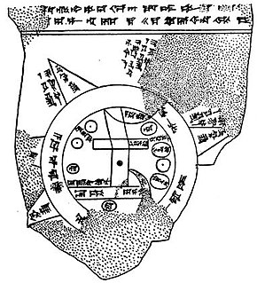
[2] The map is centered on the Euphrates, flowing from the north (top) to the south (bottom), with its mouth labelled "swamp" and "outflow".
[3] The tablet was excavated by Hormuzd Rassam at Sippar, Baghdad vilayet,[4] some 60 km north of Babylon on the east bank of the Euphrates River.
Systematic differences between the texts suggest that the tablet may have been compiled from three separate documents.
Cuneiform script labels all locations inside the circular map, as well as a few regions outside.
The two circles represent a body of water labelled idmaratum "bitter river", the salt sea.
Seven or eight triangular sections outside the water circle represent named "regions" (nagu).
"Great Wall, 6 leagues in between, where the Sun is not seen" (Akkadian: BÀD.GU.LA 6 bēru ina bi-rit a-šar Šamaš la innammaru).
– The "Great Wall" may be a mountain ridge, the "6 leagues in between" probably refer to the width of the Ocean.
The text above the map[16] (11 lines) seems to describe part of the creation of the world by Marduk, the patron god of Babylon, who parted the primeval Ocean (the goddess Tiamat) and thus created Land and Sea.
Of the Sea it says: the ruine[d] gods which he (Marduk) set[tled] inside the Sea [...] are present; the viper, the great sea-serpent inside.Next, on Land, a series of two mythical creatures ("the Anzu-bird, and scorpi[on-man]") and at least fifteen land animals are mentioned, "beasts which Marduk created on top of the res[tl]ess Sea" (i.e. on the land, visualized as a kind of giant raft floating in the Sea), among them mountain goat, gazelle, lion, wolf, monkey and female-monkey, ostrich, cat, and chameleon.
which no one can compre[hend] [i.e., the nagu extend infinitely far]The last two lines apparently recorded the name of the scribe who wrote the tablet: [...] copied from its old exemplar and colla[ted ...] the son of Iṣṣuru [the descend]ant of Ea-bēl-il[ī].Carlo Zaccagnini has argued that the design of the Babylonian map of the world may have lived on in the T and O maps of the European Middle Ages.